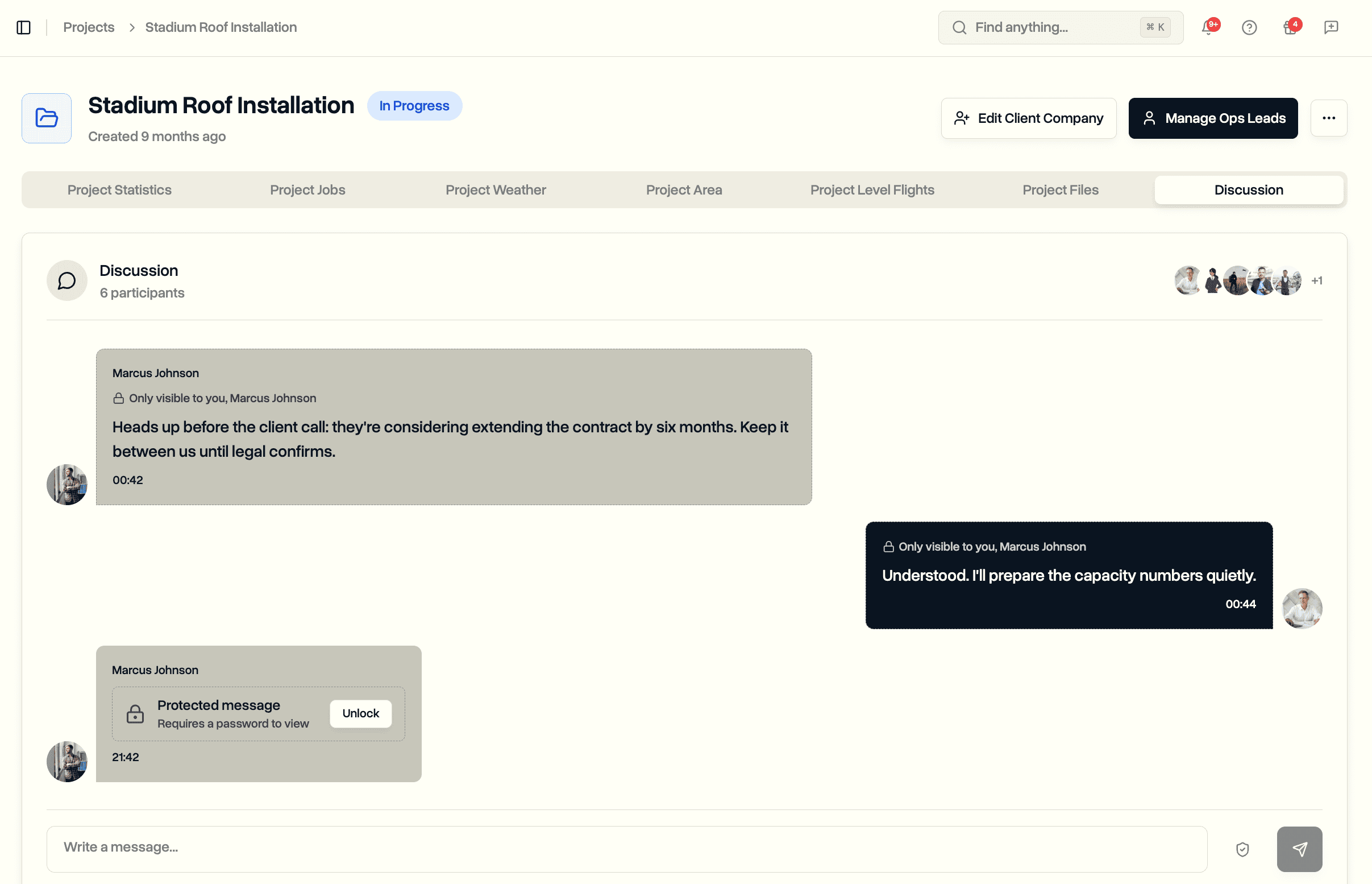
Agricultural Drones: Precision Farming Technology for Crop Monitoring and Management
Discover how agricultural drones use advanced sensors and data analytics to improve crop yields, reduce costs, and support precision farming operations.

Discover how modern SaaS platforms are transforming drone compliance from a burden into a streamlined process. Learn about real-time airspace updates, automated risk assessments, and comprehensive fleet management solutions.
Read →Discover how agricultural drones use advanced sensors and data analytics to improve crop yields, reduce costs, and support precision farming operations.
Learn how to obtain your Part 107 certification, from knowledge test prep to operational requirements and waivers for commercial drone operations.
Learn how to build a profitable drone service business covering market opportunities, FAA certification, equipment selection, niche specialization, pricing strategies, and operational management.
Discover quality assurance standards for drone inspections covering systematic data collection, safety protocols, documentation requirements, and integration with construction management systems.
Explore emerging drone applications reshaping law enforcement, healthcare delivery, industrial inspection, and infrastructure through autonomous systems and advanced capabilities in 2025.
Discover specialized business tools for drone companies, covering flight planning, fleet management, compliance tracking, and client management to scale operations efficiently.
Agricultural drones revolutionize modern farming through precise crop monitoring, targeted treatments, and efficient field mapping, delivering measurable improvements in yields and resource efficiency.
Drone data processing transforms raw aerial imagery into accurate 3D models, orthomosaics, and actionable insights for construction, agriculture, and inspection operations.
Ground control points transform drone mapping from approximate aerial photography to survey-grade accuracy, enabling professional applications across construction, agriculture, and environmental monitoring.
DJI cloud provides automated flight data backup, synchronization across devices, and centralized storage for drone operators seeking efficient data management solutions.
Professional drone operators need specialized liability insurance covering property damage, personal injury, equipment loss, and regulatory compliance requirements.
Master EASA drone regulations including operational categories, pilot certification, registration, remote ID, and compliance strategies for Europe.
Learn FAA drone license requirements, Part 107 certification pathways, testing procedures, and operational guidelines for commercial pilots.
Effective drone equipment management involves tracking hardware, software, certifications, and maintenance to ensure operational efficiency, safety, and regulatory compliance in scalable drone programs.
Master weather assessment for safe drone operations including wind, temperature, humidity, and visibility management strategies.
Stop emailing files and sending Dropbox links. Give your drone clients secure access to their projects, flight data, and deliverables through a professional client portal.
Learn which drone license you need based on your flying purpose—recreational or commercial—and understand FAA requirements like Part 107, registration, and special waivers for safe, legal drone operations.
Comprehensive guide to drone flight reports covering regulatory compliance, data fields, automation, and best practices for transforming flight data into actionable insights for professional operations.
Learn how to access, export, and interpret DJI logs to analyze flight data, troubleshoot issues, ensure regulatory compliance, and optimize drone performance with detailed flight records.
Learn how to obtain your EU drone license by understanding EASA regulations, completing training programs, passing certification exams, registering as an operator, and maintaining compliance for legal drone operations across Europe.
Learn how to scale a drone business by building operational systems, developing specialized services, optimizing marketing, and managing finances for sustainable growth and competitive advantage in commercial drone operations.
Discover comprehensive drone operations software that streamlines mission planning, real-time monitoring, compliance tracking, and fleet management for commercial UAV operations, ensuring efficiency, safety, and regulatory adherence.
Master drone mapping with advanced photogrammetry, high-resolution sensors, and precise flight planning to produce accurate, detailed maps and 3D models for construction, agriculture, surveying, and environmental applications.
Master effective drone flight planning with advanced software, terrain analysis, environmental considerations, and safety protocols to ensure successful missions, optimal data collection, and regulatory compliance for professional operations.
Master the complexities of multi-aircraft operations through comprehensive fleet management systems that optimize scheduling, ensure compliance, reduce costs, and transform operational chaos into competitive advantage.
Discover how drone technology transforms power line inspections by eliminating climbing risks, reducing costs by 80%, and delivering superior data quality through thermal imaging, LiDAR, and automated analysis systems.
Master the SORA methodology for drone operations beyond standard limitations. Learn to conduct systematic risk assessments, implement effective mitigation measures, and secure regulatory approval for complex commercial missions.
Discover how drones revolutionize cell tower inspections by eliminating climbing risks, reducing costs by 78%, and delivering superior data quality through advanced sensors and automated flight systems.
Explore how UTM systems revolutionize drone traffic coordination through automated conflict resolution, real-time airspace management, and scalable safety solutions for commercial operations in increasingly crowded skies.
Discover essential drone insurance coverage types, including hull, liability, payload, and ground risk protection, tailored for commercial operators to mitigate risks and ensure regulatory compliance in aerial operations.
Drone technology revolutionizes wind turbine inspections by enhancing safety, reducing costs, and providing detailed visual and thermal data for proactive maintenance and improved operational efficiency.
Forestry inspections with drones revolutionize forest management by providing rapid, safe, and detailed aerial surveys for early disease detection, fire risk assessment, wildlife monitoring, and precise forest inventory analysis.
LiDAR for drones enables precise 3D mapping, industry applications like surveying, forestry, and construction, and offers advanced sensor options, making aerial data collection faster, more accurate, and operationally flexible.
Visual Line of Sight is essential for safe drone operations, requiring direct visual contact, proper equipment, and environmental awareness to ensure regulatory compliance and operational safety across various industries.
Real Time Kinematic (RTK) positioning delivers centimeter-level GPS accuracy in real time, revolutionizing drone operations, construction, agriculture, and surveying with precise, reliable positioning technology.
Drones for surveying revolutionize data collection by providing fast, accurate, and cost-effective aerial mapping solutions with advanced sensors, photogrammetry, and operational considerations across various industries.
Drones for site security offer advanced perimeter monitoring, rapid incident response, and integration with existing systems, enhancing safety, reducing costs, and providing real-time aerial intelligence for comprehensive site protection.
Discover how drones for asset inspection revolutionize industrial maintenance by providing safer, faster, and cost-effective solutions with advanced sensors, precise data collection, and strategic implementation methods.
Drones for construction inspections provide fast, safe, and detailed site assessments, capturing high-resolution images, thermal data, and 3D models to enhance safety, efficiency, and project documentation.
U-space is Europe innovative drone traffic management framework that enables safe, autonomous, and efficient integration of unmanned aircraft into crowded airspace through digital services and dynamic airspace control.
Discover how advanced drone obstacle avoidance systems utilize sensors, AI, and algorithms to ensure collision-free flights across various environments and industries, enhancing safety and operational efficiency.
Effective drone maintenance involves systematic inspections, scheduled intervals, component-specific care, and environmental considerations to ensure optimal fleet performance, safety, and regulatory compliance in demanding operational environments.
Understanding the flight time of a drone involves factors like battery capacity, payload, environmental conditions, and flight patterns, which all influence how long your drone can stay airborne during missions.
Understanding the different types of airspace, including classes A through G and special use zones, is essential for safe, compliant drone and aircraft operations across controlled and uncontrolled regions.
Learn about UAS pilot training requirements, pathways, certification processes, industry-specific skills, ongoing education, and future trends to ensure safe, compliant, and professional drone operations.
Drone flight data monitoring enables proactive fleet management by capturing, analyzing, and optimizing telemetry data to improve safety, efficiency, and regulatory compliance in commercial drone operations.
Learn how to file a NOTAM effectively for aviation activities, including drone operations, fireworks, and construction, ensuring safety, compliance, and proper airspace notification procedures.
Learn what METAR is, how it provides essential aviation weather data, and how drone operators can interpret these coded reports for safe and efficient flight planning in various weather conditions.
Understanding drone airspace, regulations, restrictions, and authorization tools is essential for safe, compliant, and efficient drone flight planning in controlled, uncontrolled, and no-fly zones within the National Airspace System.
This comprehensive drone operation risk assessment guide covers hazard identification, environmental factors, equipment reliability, human factors, and mitigation strategies to ensure safe, compliant, and efficient drone flights.
Remote ID is a crucial regulatory system that broadcasts drone identification and flight data, enhancing safety, security, and accountability for all drone operators in U.S. airspace.
Effective tracking of drone pilot flight hours ensures regulatory compliance, enhances safety, supports maintenance, and boosts credibility with clients through accurate, automated, or manual logging methods tailored to professional drone operations.
Learn effective strategies for managing drone fleet maintenance through systematic inspections, predictive techniques, documentation, and cost optimization to ensure operational reliability and regulatory compliance at scale.
Learn how to streamline drone mission planning with systematic strategies, automation, and technology integration to improve efficiency, safety, and data quality across various operational scenarios.
Understanding no-fly zones and restricted airspace is essential for drone operators to ensure legal compliance, navigate federal and local restrictions, and avoid penalties in complex airspace environments.
Drone use in construction enhances site surveying, progress tracking, safety inspections, and asset management, delivering faster, safer, and more accurate project outcomes while reducing costs and improving overall efficiency.
A comprehensive drone pre-flight checklist template ensures safety, regulatory compliance, equipment inspection, weather assessment, and efficient flight planning, helping professional pilots prevent failures and execute successful drone operations.
DroneBundle unveils comprehensive live tracking capabilities with real-time telemetry monitoring, flight replay analytics, and a redesigned operations dashboard. Experience complete fleet visibility and data-driven insights.
DroneBundle launches comprehensive weather integration with real-time data, automated safety scoring, and intelligent flight planning. Discover how weather-aware operations reduce incidents and improve efficiency.
Discover how modern SaaS platforms are transforming drone compliance from a burden into a streamlined process. Learn about real-time airspace updates, automated risk assessments, and comprehensive fleet management solutions.
Explore Beyond Visual Line of Sight (BVLOS) drone operations and their transformative impact on industries. Learn about the technology, regulations, and real-world applications that are revolutionizing autonomous drone missions.
Ensure safe and successful drone operations with our comprehensive pre-flight checklist. From mission planning to post-flight procedures, learn the essential steps every drone pilot should follow for professional operations.