What are the Best Places to Fly Drones?
The best places to fly drones include Bureau of Land Management (BLM) public lands, most national forests, designated state parks, local parks without drone restrictions, private property with permission, and AMA-approved flying fields. These locations offer legal flying opportunities while providing scenic landscapes and minimal airspace conflicts for recreational and commercial pilots.
Finding the best places to fly drones requires understanding federal regulations, land management rules, and local restrictions. With over 245 million acres of BLM land and 193 million acres of national forest open to drone pilots, the United States offers extensive flying opportunities for those who know where to look.
The FAA establishes airspace rules that apply everywhere, but land use permissions vary significantly between federal agencies, state governments, and local jurisdictions. National parks prohibit drone use entirely, while BLM lands generally permit flying with minimal restrictions. Understanding these distinctions helps pilots identify legal flying locations and avoid costly violations.
Table of contents
- Understanding drone flying regulations
- BLM lands and public property
- National forests and wilderness areas
- State parks and local parks
- National parks and prohibited areas
- Best places to fly drones by region
- Tools for finding legal flying spots
- Frequently asked questions
- Implementation considerations
- In summary
Understanding drone flying regulations
Before exploring specific locations, pilots must understand the regulatory framework governing drone operations. The FAA controls airspace, while various land management agencies control surface access and takeoff permissions.
FAA airspace requirements
All drone pilots must follow FAA airspace regulations regardless of where they fly. Key requirements include maintaining altitude below 400 feet AGL, keeping the drone within visual line of sight, and avoiding flight over people without proper authorization.
Controlled airspace near airports requires authorization through LAANC or the FAA DroneZone portal. Class B, C, D, and surface E airspace designated for airports all require prior approval. Class G uncontrolled airspace allows flight up to 400 feet without authorization in most cases.
Remote ID compliance is now mandatory for all drones requiring FAA registration. Pilots must ensure their aircraft broadcasts identification and location information unless operating within an FAA-Recognized Identification Area (FRIA).
Certification requirements
Recreational pilots must complete The Recreational UAS Safety Test (TRUST) and carry proof while flying. Commercial operations require Part 107 certification, which involves passing a knowledge test covering airspace, weather, and regulations.
Understanding what drone license you need depends on your intended use. Photography for personal use falls under recreational rules, while any commercial purpose requires Part 107 certification. The FAA drone license process takes most pilots two to four weeks to complete.
BLM lands and public property
Bureau of Land Management lands represent the most drone-friendly public property in the United States. The BLM manages approximately 245 million acres across 12 western states, with most areas permitting drone operations under standard FAA rules.
Why BLM land works for drone pilots
The BLM has largely deferred drone regulation to the FAA, meaning pilots can fly on most BLM property without additional permits. According to the Bureau of Land Management, drone use is generally permitted subject to FAA airspace restrictions and specific area closures.
BLM lands offer diverse terrain including deserts, canyons, mountains, and coastal areas. Popular locations near Moab, Utah provide access to dramatic red rock formations outside the restricted national park boundaries. Oregon's high desert and Nevada's basin and range province offer equally impressive landscapes.
BLM restrictions to know
Wilderness areas managed by BLM prohibit drone use under the Wilderness Act of 1964. The BLM manages 263 wilderness areas where motorized and mechanical equipment, including drones, cannot operate. Check the BLM National Data map layer before planning flights in remote areas.
Temporary flight restrictions apply during wildfire suppression operations. Flying drones near active wildfires carries criminal penalties and endangers firefighting aircraft. The FAA issues TFRs for fire zones that override normal flying permissions.
Some BLM areas near military installations or critical infrastructure may have additional restrictions. Always verify current conditions through the B4UFLY app or FAA airspace maps before flying.
National forests and wilderness areas
The US Forest Service manages 193 million acres of national forest land. Unlike national parks, most national forest areas permit drone operations for recreational and commercial purposes.
Flying in national forests
Drone pilots can generally fly in national forests while following FAA regulations and forest service guidelines. The Forest Service requests pilots maintain safe distances from wildlife, avoid disturbing other visitors, and follow Leave No Trace principles.
Some national forests have implemented local restrictions on drone use. Popular areas with heavy visitor traffic may limit flying during peak seasons. Contact the local ranger district before planning flights in unfamiliar forests to verify current policies.
Commercial drone operations in national forests may require special use permits depending on the activity and location. Surveying operations and professional photography often need advance coordination with forest managers. Construction and infrastructure projects on forest land require additional permitting beyond standard airspace authorization.
Wilderness area prohibitions
Congressionally designated wilderness areas within national forests prohibit drone use. The Wilderness Act classifies drones as both motorized equipment and mechanical transport, barring takeoff, landing, and operation within wilderness boundaries.
The National Wilderness Preservation System includes over 800 wilderness areas totaling 111 million acres. These protected lands often border or surround accessible national forest areas, creating patchwork flying zones that require careful flight planning.
Maps showing wilderness boundaries are essential for pilots operating near protected areas. Flying over wilderness from adjacent legal takeoff points remains prohibited under current interpretation of the regulations.
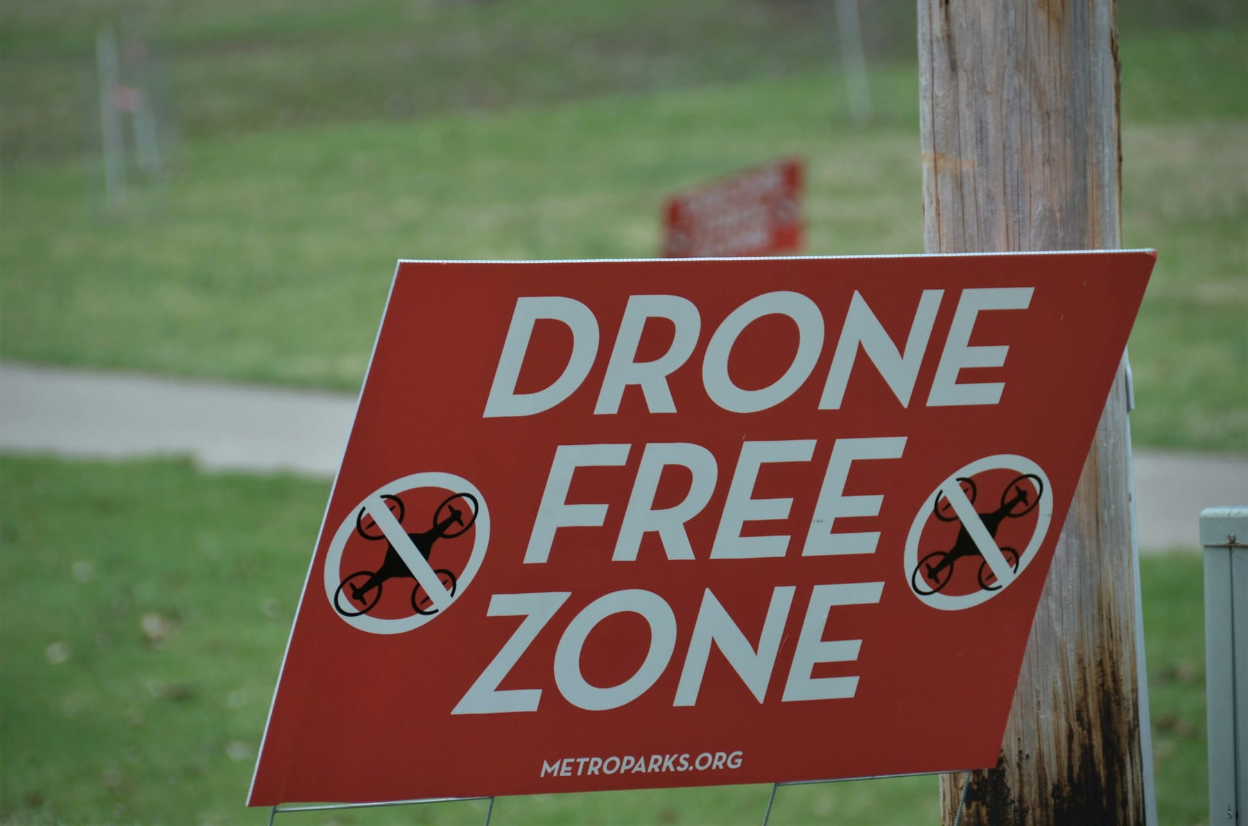
State parks and local parks
State park drone policies vary significantly across jurisdictions. Some states welcome drone pilots with minimal restrictions, while others require permits or prohibit flying entirely. Researching specific park rules before visiting prevents wasted trips and potential citations.
State park policies by approach
States generally fall into three categories regarding drone use in state parks:
Permissive states allow drone flying in most state parks with standard FAA compliance. Utah, Arizona, and Nevada maintain relatively open policies that attract drone pilots to their scenic public lands.
Permit-required states allow flying with advance authorization. California, for example, requires permits for drone operations in state parks. The application process varies by park and intended use.
Restrictive states prohibit or severely limit drone use in state parks. Hawaii bans drones in all state parks, while other states restrict flying to designated areas or times.
Local park regulations
City and county parks follow local ordinances that may differ from state policies. Many municipalities prohibit drone flying in developed park areas due to safety concerns and noise complaints. Some cities have designated drone parks or flying fields where operations are encouraged.
Check local government websites or contact parks departments before flying in municipal parks. Violations of local ordinances can result in fines even when FAA requirements are met.
National parks and prohibited areas
National parks represent the most significant restriction for drone pilots in the United States. The National Park Service banned drones in 2014 through Policy Memorandum 14-05, citing safety concerns for visitors, staff, and wildlife.
Understanding the national park ban
The prohibition applies to launching, landing, or operating drones within national park boundaries. Violations carry penalties up to $5,000 in fines and six months imprisonment. Park rangers actively enforce the ban, and pilots have faced prosecution for unauthorized flights.
The NPS has not created a general permit system for recreational drone use. Special use permits for film and photography remain theoretically available but are rarely granted and require extensive documentation and insurance.
Understanding no-fly zones and restricted areas helps pilots avoid unintentional violations. National parks often border BLM land or national forests where flying is permitted, but crossing into park airspace remains prohibited.
Other prohibited locations
Beyond national parks, several location categories restrict or prohibit drone operations. Public safety and emergency operations may have temporary access to restricted areas, but recreational and most commercial flights must avoid:
- Military installations and restricted airspace
- Stadiums and sporting events during games
- Emergency response scenes and disaster areas
- Critical infrastructure without authorization
- Private property without owner permission
The USA aviation maps and B4UFLY app display most permanent restrictions. Temporary flight restrictions require checking NOTAMs through the FAA system or understanding how to file a NOTAM for your own operations.
Best places to fly drones by region
The United States offers exceptional drone flying locations across diverse landscapes. These destinations combine legal flying access with photogenic scenery and reasonable travel logistics.
Southwest region
The American Southwest provides arguably the best drone flying opportunities in the country. BLM lands surrounding Utah's national parks offer canyon country landscapes without the flight restrictions.
Moab area BLM lands provide access to red rock formations, canyon overlooks, and desert vistas. The Colorado River corridor and areas surrounding Canyonlands offer spectacular footage without state park restrictions. Note that Dead Horse Point State Park prohibits drones March through October, with winter permits available November through February.
BLM lands near Lake Mead in Nevada provide desert canyon terrain without the permit requirements of Nevada State Parks. Valley of Fire State Park prohibits drones except with approved photography permits requiring 30+ days advance notice, FAA certification, and liability insurance.
Arizona Strip BLM lands north of the Grand Canyon offer remote flying with minimal other visitors. The Vermilion Cliffs area provides colorful geology accessible by high-clearance vehicle.
Pacific Northwest
Oregon and Washington combine coastal scenery with volcanic landscapes accessible to drone pilots.
Oregon Coast public beaches allow drone operations in many areas outside designated state parks. Sea stacks, tide pools, and dramatic cliffs provide compelling subjects. Check specific beach access rules as some areas have seasonal wildlife closures.
Central Oregon BLM lands near Bend offer high desert terrain with volcanic features. The Newberry Volcanic Monument permits drone use in most areas outside designated wilderness.
Mountain West
Colorado, Wyoming, and Montana provide alpine and prairie landscapes with extensive public land access.
BLM lands in western Colorado near Grand Junction offer desert canyon terrain similar to Utah. Ruby Canyon along the Colorado River provides river corridor flying without permit requirements.
Wyoming BLM lands surrounding Yellowstone and Grand Teton provide flying opportunities near the restricted national parks. The Wind River range foothills and Red Desert offer remote flying with dramatic scenery.
Tools for finding legal flying spots
Several resources help pilots identify legal flying locations and current airspace conditions before departing for the field.
FAA resources
The B4UFLY app provides real-time airspace information based on GPS location. The app displays controlled airspace, temporary restrictions, and notices relevant to drone operations. It integrates with weather data to support pre-flight planning.
FAA DroneZone handles registration and airspace authorizations for controlled airspace. The LAANC system provides near-real-time authorization for flights in participating airports' airspace. Professional operators also benefit from real-time weather integration to ensure safe flying conditions.
Land management resources
BLM National Data provides interactive maps showing land ownership and management status. The map layers identify wilderness areas, recreation sites, and special management zones.
US Forest Service interactive maps display national forest boundaries, wilderness areas, and ranger district contacts. These tools help identify forest lands adjacent to restricted areas.
Commercial planning tools
Professional operators benefit from drone operations software that integrates airspace data with project management. These platforms support flight data monitoring and compliance documentation required for commercial work.
Operations requiring access to agriculture and environmental sites or surveying and inspection projects need planning tools that account for both airspace and land access permissions.
Frequently asked questions
Can I fly my drone at the beach?
Beach access depends on ownership and local regulations. Federal beaches managed by the BLM or Forest Service generally allow drone flying. State beaches vary by jurisdiction, with some requiring permits and others prohibiting drones entirely. Private beaches require owner permission. Always check specific beach policies and be aware of wildlife protection zones that may restrict flying seasonally.
Do I need permission to fly over private property?
FAA regulations do not explicitly require permission to fly over private property at legal altitudes. However, many states have enacted drone privacy laws that may restrict overflights without consent. Takeoff and landing on private property always requires owner permission. For commercial operations, securing property access simplifies risk assessment and client relations.
What happens if I accidentally fly in a national park?
Enforcement depends on park ranger discretion and circumstances. First-time violators may receive warnings or citations with fines up to $5,000. Repeated or egregious violations can result in equipment seizure and criminal charges. If you realize you've entered park airspace, land immediately in a legal area and document the incident. Having proper drone insurance helps manage unexpected legal exposure.
Are there designated drone flying areas?
The Academy of Model Aeronautics (AMA) maintains flying fields specifically designated for drone and RC aircraft use. FAA-Recognized Identification Areas (FRIAs) allow flying without Remote ID requirements. Some municipalities have created drone parks with designated flying zones. These locations provide controlled environments ideal for practice and skills development.
Implementation considerations
Finding the best places to fly drones requires systematic research before each flying session. Develop a pre-flight research routine that verifies airspace authorization, land access permission, and current conditions at your intended location.
Start with the B4UFLY app to confirm airspace status and any active NOTAMs or TFRs. Then verify land ownership and management using BLM, Forest Service, or state land maps. Contact local ranger stations or land managers when policies are unclear. This research investment prevents wasted travel and potential violations.
Consider joining local drone clubs or online communities focused on your flying region. Experienced pilots often share location knowledge and current conditions that supplement official resources. Community knowledge helps identify hidden gems and avoid problem areas.
Build a personal database of verified flying locations with GPS coordinates, access directions, and contact information. Document permit requirements, seasonal restrictions, and parking situations for each site. This reference saves research time for return visits and helps plan efficient flying trips.
In summary
The best places to fly drones combine legal access, scenic terrain, and practical logistics. BLM lands offer the most permissive flying environment with over 245 million acres available across the western states. National forests provide additional options in most areas outside designated wilderness. State and local parks require individual research as policies vary significantly.
Understanding the distinction between airspace regulations and land use permissions helps pilots navigate the complex regulatory environment. FAA rules apply everywhere, but takeoff and landing permission depends on who manages the land. National parks prohibit drone use entirely, while adjacent BLM or forest lands may welcome pilots.
Successful drone pilots develop systematic research habits that verify both airspace and land access before every flight. Investing time in pre-flight planning prevents wasted trips, avoids violations, and identifies the best opportunities for aerial photography and videography.
Ready to plan your drone flights?
Professional drone operations require systematic flight planning that accounts for airspace requirements, weather conditions, and project logistics. Whether you're flying recreationally or building a drone service business, organized operations lead to better results and fewer complications.
Start your free trial today - no credit card required.
Or book a demo to see how DroneBundle streamlines mission planning and regulatory compliance for professional drone operations.