WebODM is free, open-source drone mapping software that turns overlapping drone photos into orthomosaics, elevation models, point clouds and 3D models on your own computer, or in the cloud through WebODM Lightning from $24 a month billed yearly. For teams that want maps without running a server, DroneBundle builds maps, 3D models and thermal maps on the job, next to the pilots, flight records, clients and invoices, from $199 a month.
WebODM is not the project it was a year ago. On April 6, 2026 it split from the OpenDroneMap project, switched to its own processing engine and made its installers free. Instructions written before that date, such as installing OpenDroneMap first and adding WebODM on top, no longer match the software. If you are new to the workflow, start with how drone data processing works.
This guide covers who makes what today, what each route costs, how much RAM your photo counts need, how ground control works, and what WebODM leaves for you to run yourself. For the wider market, our drone mapping software roundup ranks every option with prices.
What is WebODM, and is it still part of OpenDroneMap?
WebODM is no longer part of OpenDroneMap. Its lead developer announced on April 6, 2026 that WebODM had decoupled from OpenDroneMap and would continue as a separate, independent project, with its code now under the WebODM organisation on GitHub.
The split matters because WebODM and OpenDroneMap now ship different engines and different installers. WebODM processes with ODX, a fork of the ODM engine, and NodeODX replaces NodeODM as the processing node. OpenDroneMap keeps the ODM name, the original command line toolkit and its own installer.
| Name | What it is in November 2026 | Who runs it | Cost |
|---|---|---|---|
| ODM | Command line toolkit that turns drone images into point clouds, 3D models, orthophotos and elevation models | OpenDroneMap | Free, AGPL-3.0 |
| NodeODM | Processing node that lets other software send ODM jobs over a network | OpenDroneMap | Free, AGPL-3.0 |
| OpenDroneMap Installer | Paid Windows installer with installation support | OpenDroneMap | $64 Standard or $149 Business, one-time |
| WebODM | Browser interface for projects, processing, viewing and measuring | WebODM | Free, AGPL-3.0, free installers |
| ODX and NodeODX | WebODM's processing engine and node, forked from ODM and NodeODM | WebODM | Free, AGPL-3.0 |
| WebODM Lightning | Cloud processing service using the LGT engine, which is only available there; it funds WebODM development | UAV4GEO | Free credits to start, then plans from $24 a month billed yearly |
Existing WebODM installs keep working. The WebODM migration guide tells Docker users to run ./webodm.sh update, and tells anyone who bought an installer before April 6, 2026 to install the new free version over the old folder after a backup.
How much does WebODM cost?
WebODM costs nothing to download and run: the software is open source under AGPL-3.0, and since April 2026 the official Windows and macOS installers on webodm.org are free too. What you pay for instead is the computer, the cloud service, or the paid support on the OpenDroneMap side.
| Route | Price (checked November 2026) | What you get |
|---|---|---|
| WebODM, self-hosted | Free | Installer for Windows and macOS, Docker for Linux. You supply the hardware |
| OpenDroneMap Installer, Standard | $64 one-time (Windows) | OpenDroneMap's installer with 1 year of installation support |
| OpenDroneMap Installer, Business | $149 one-time (Windows) | The same installer with 24-hour priority installation support |
| WebODM Lightning, Pay As You Go | Priced per map | Up to 1,500 images per map |
| WebODM Lightning Starter | $24 a month, billed yearly | 12 maps per 30 days, then per map; 1,500 images per map; 25 GB storage |
| WebODM Lightning Pro | $35 a month, billed yearly | Unlimited maps; 1,500 images per map; 100 GB storage |
| WebODM Lightning Business | $99 a month, billed yearly | Unlimited maps; 3,000 images per map; 1,000 GB storage |
Lightning prices and limits are from its pricing page; new accounts get 150 free credits and a 30-day money-back guarantee. OpenDroneMap's download page says its installer has no free trial and that the Standard and Business editions differ only in support speed.
What does a 500-photo map cost on each route?
A 500-photo map is a useful yardstick, because it is roughly where a laptop stops being enough. Here is the same job on each route, using the published figures above and the RAM table in the next section:
| Route | Cost for 15 maps of 500 photos a month | Catch |
|---|---|---|
| WebODM on your own computer | $0 in software | Needs about 32 GB of RAM per the WebODM docs, plus your time to run it |
| WebODM Lightning Pro | $35 a month, billed yearly | Unlimited maps, 2 processing at once |
| DroneBundle Solo | $249 a month: $199 with 50 credits, plus a $50 pack of 50 credits | 500 photos = 5 credits, so 15 maps use 75; the 25 spare credits never expire |
Self-hosting looks free until you price the machine and the hours. Our photogrammetry software comparison works through a year of processing with labor counted, and the DroneBundle price includes the jobs, pilots, flight records, clients and invoicing that WebODM does not do.
What hardware does WebODM need?
WebODM needs at least a 64-bit CPU, 20 GB of free disk and 8 GB of RAM, and its download page says 8 GB will not process more than about 100 images. The WebODM hardware requirements recommend 16 GB of RAM and 100 GB of disk as the starting point, then more RAM in line with your photo count.
| Images per map | RAM, or RAM plus swap |
|---|---|
| 40 | 4 GB |
| 250 | 16 GB |
| 500 | 32 GB |
| 1,500 | 64 GB |
| 2,500 | 128 GB |
| 3,500 | 192 GB |
| 5,000 | 256 GB |
The docs call these conservative estimates: image size, flight altitude and processing settings all change memory use. Run your typical job through the table before you buy a machine. A roof captured in 250 photos fits a 16 GB laptop, but a 1,500-photo site map wants a 64 GB workstation.
Docker, operating systems and GPUs
On Windows, the WebODM installer runs natively without Docker. On macOS the installer manages Docker for you, and on Linux you install with Docker directly; the docs tell Windows and macOS Docker users to give Docker more than 4 GB of RAM in its settings (16 GB is better). Apple Silicon is supported, Windows on Arm is not.
GPU acceleration works on Linux and WSL with a CUDA-capable NVIDIA card, and the November 4, 2026 release added RTX 50 series support. WebODM's interface alone needs only 1 or 2 GB of RAM, so you can run the interface on a small server and send processing to a bigger machine or to Lightning.
The docs give no fixed processing time per photo. More CPU cores speed processing up but can also raise memory use, and a job without enough memory can fail.
What maps and models does WebODM produce?
WebODM produces georeferenced orthomosaics, point clouds, elevation models, textured 3D models and gaussian splats from aerial images, per its GitHub README. Its elevation outputs include both a digital surface model and a digital terrain model; our guide to DSM vs DTM explains which one to use for volumes, drainage and contours.
The Lightning pricing page lists what every Lightning plan includes, which is a fair map of the feature set:
- Maps. Orthomosaics in GeoTIFF, JPEG, PNG and KML, with plant health and thermal index maps.
- Elevation. DSM and DTM, elevation contours, elevation profiles and slope maps.
- 3D. Textured models (OBJ, GLB, 3D Tiles), point clouds (LAS, LAZ, PLY, CSV), and gaussian splats.
- Measuring. 2D and 3D measurements, volume measurements and annotations, in metric or imperial units.
- Inputs. RGB, multispectral and thermal images, with RTK, PPK and ground control support.
Processing settings are where WebODM rewards experience, and good results start with flight planning that gives enough overlap. The docs carry an options guide, and choices such as orthophoto resolution or DEM settings change both quality and memory use. For what a finished map should look like, see our explainer on orthomosaic images, and for capturing a structure rather than a flat site, our guide to making a 3D model from drone photos.
How do ground control points work in WebODM?
WebODM reads ground control points from a plain text file called gcp_list.txt in the base of the project, and detects it automatically. The first line names the coordinate system and every other line ties one surveyed point to one pixel in one photo, per the WebODM GCP file format.
+proj=utm +zone=10 +ellps=WGS84 +datum=WGS84 +units=m +no_defs
544256.7 5320919.9 5 3044 2622 IMG_0525.jpg gcp01
544157.7 5320899.2 5 4193 1552 IMG_0585.jpg gcp02
544033.4 5320876.0 5 1606 2763 IMG_0690.jpg CHK-A
Each line reads: easting (geo_x), northing (geo_y), elevation (geo_z), pixel column, pixel row, image file name, then an optional label. The header can be a PROJ string, an EPSG code such as EPSG:4326, or WGS84 UTM 16N style text.
| GCP rule from the WebODM docs | Why it matters |
|---|---|
| At least 5 GCPs; 8 to 10 for larger projects | Spread evenly, with some near the corners and some in the center |
| Each point found in at least 3 photos | 5 points x 3 photos = at least 15 lines after the header |
| File names are case-sensitive, no spaces | IMG_0001.jpg is not IMG_0001.JPG; write a space as %20 |
| Use 0.0, never NaN, for a missing elevation | NaN can make processing fail |
| Prefix a label with CHK- to make it a checkpoint | Checkpoints stay out of processing and measure accuracy afterwards |
Add --force-gps to use RTK image positions with a GCP file |
Otherwise the GCP file drives georeferencing |
The WebODM GCP docs give no single accuracy figure, because accuracy depends on your control, overlap and flying height. Checkpoints, which arrived in the November 2026 release, are how you measure it on your own job. For target placement, survey methods and how many points a site needs, read our full guide to ground control points.
WebODM vs Pix4D: what is the difference?
WebODM is free, open-source software you run and maintain yourself, while Pix4D is commercial software sold by subscription with vendor support. Both turn drone photos into orthomosaics, elevation models, point clouds and 3D models, and both accept ground control.
| WebODM | Pix4D | |
|---|---|---|
| Licence | Open source, AGPL-3.0 | Commercial subscription |
| Software price | Free | PIX4Dmapper $3,990 a year; PIX4Dmatic from $2,290 a year (Analyst) |
| Where it runs | Your computer (Windows, macOS, Linux) or Lightning cloud | Desktop, plus PIX4Dcloud |
| Support | Community, documentation, paid installer support on the OpenDroneMap side | Vendor support with the subscription |
| Who maintains the computer | You | You for desktop, Pix4D for cloud |
Pix4D prices are from Pix4D's pricing pages, checked November 2026; PIX4Dmatic's cheapest Analyst plan does not build orthomosaics, so the full breakdown is in our Pix4D pricing guide. WebODM fits teams with the hardware and the time to tune settings; survey firms comparing more tools can read our drone surveying software guide. Pix4D fits teams whose clients specify it or who want a vendor to call.
Where does WebODM fall short for a drone business?
WebODM makes maps, and that is all it is built to do. It has no jobs, no pilot schedule, no flight records, no maintenance tracking, no client portal and no invoicing, and on the self-hosted route you also run the server, the updates, the backups and the security.
The gaps show up the week work gets busy:
- The map is not the job. WebODM organises photos into projects and tasks, but who flew it, when, with which aircraft and for which client lives somewhere else.
- Flight records stay separate. WebODM's feature list has no flight log records, so hours, battery cycles and the maintenance log an auditor asks for sit in another tool.
- Billing starts from scratch. There is no link from a delivered map to an invoice.
- Someone owns the server. Updates, disk space, Docker settings, failed tasks that ran out of RAM and the April 2026 migration all land on whoever set it up.
Those gaps are why the best drone management software list exists at all. A drone service company running WebODM for processing still needs a second system for the operation around each map.
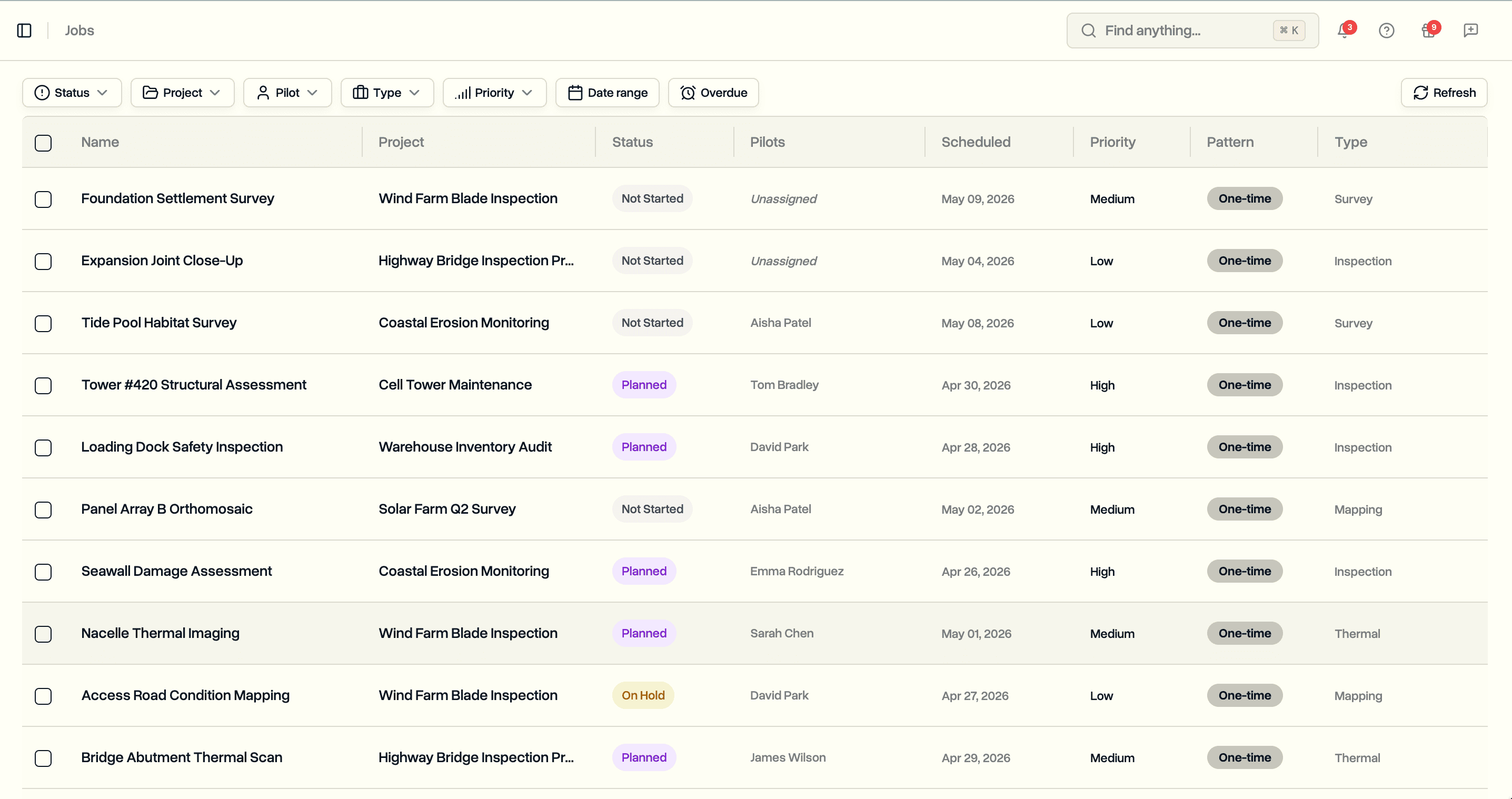
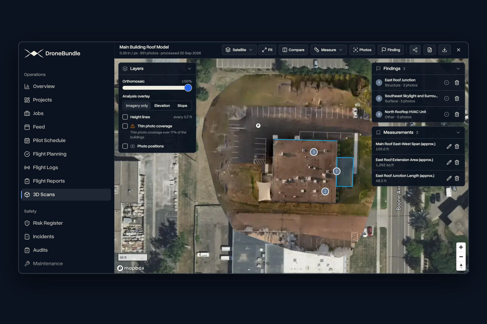
The DroneBundle Jobs page lists every job across projects with its status, pilot and dates. Maps live inside those jobs instead of in a separate tool, which is what drone fleet management software adds around processing.
What is the best WebODM alternative without a server?
DroneBundle is the best WebODM alternative for teams that want drone mapping without installing or running anything: you upload the photos to the job, see the credit cost, and start processing in the browser. The map, 3D model or thermal map then sits on the same job as the pilot, the flight records, the client and the invoice.
1. DroneBundle: best for mapping inside the whole drone operation
DroneBundle is best for drone service companies and enterprise drone programs that deliver maps, 3D models and inspection reports to clients and want the jobs, pilots, flight records, equipment, maintenance, clients and invoicing in the same place. There is no install, no server and no RAM to size.
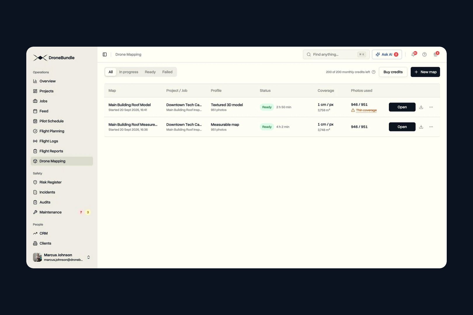
Starting a map takes one dialog. You name it and pick the photos already on the job (or add a ZIP). DroneBundle builds the map and the 3D model, offers a thermal map when it finds DJI thermal photos, and shows how many credits the map uses before you start.
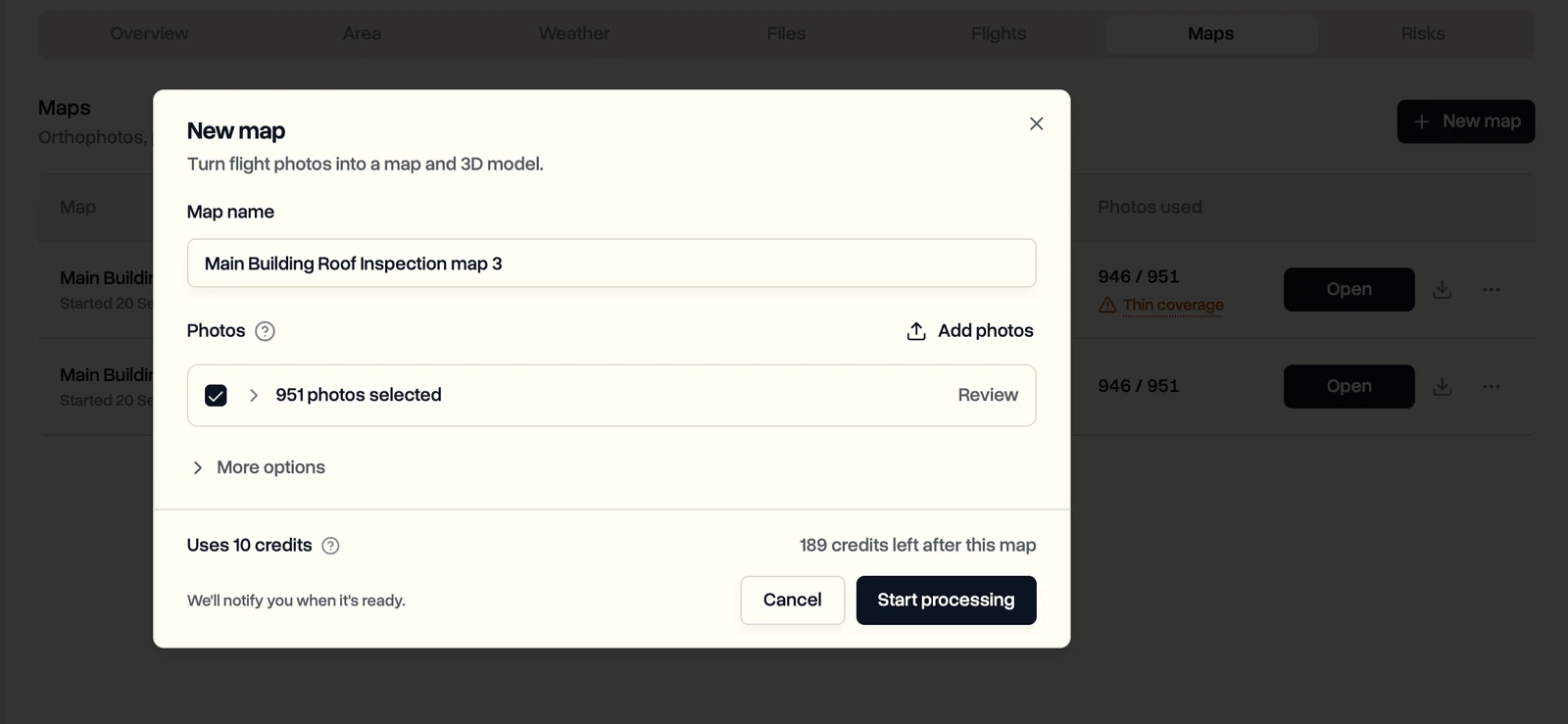
The New map dialog shows 951 photos selected and a cost of 10 credits, with 189 left after this map. One credit covers up to 100 photos, rounded up, and each map takes 10 to 1,500 photos.
Every plan includes mapping: Solo is $199 a month with 50 credits, Team is $499 a month with up to 10 team members and 200 credits, and Enterprise starts at $1,490 a month. Extra credits are $1 each, bought 50 at a time, and never expire.
What you can do with a finished map:
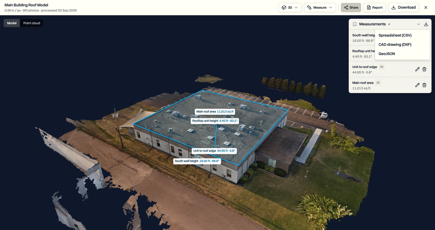
- Measure. Distances, areas, heights, height profiles and stockpile volumes, with Traced edge, Lowest point or Set level bases (see 3D measuring).
- Read the terrain. The elevation overlay colours the site by height, and the Surface model and Terrain model download as GeoTIFF files.
- Record findings. Pin a finding with a condition rating, notes and repair cost, and open the original drone photos that captured that spot.
- Deliver. Build an inspection report PDF, or share a browser link the client opens without signing in.
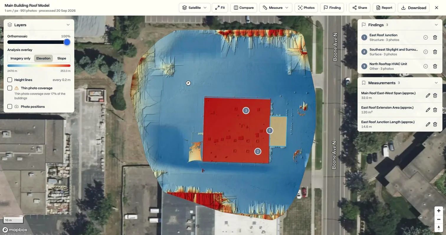
The elevation overlay shows the building and the ground around it coloured by height. The same map holds saved measurements, which export to a spreadsheet, a CAD drawing or GeoJSON.
Around the map, DroneBundle runs the operation: flight logs from DJI, PX4, ArduPilot, Autel and Parrot in one record, pilot scheduling, maintenance from flight hours and battery cycles, a client portal, a CRM and invoices built from approved flights. The full feature list is on the drone mapping page.
2. WebODM Lightning: best for low-cost cloud processing
WebODM Lightning is best for pilots who like WebODM but do not want to buy a 64 GB workstation. It processes in the cloud from $24 a month billed yearly, up to 1,500 images per map (3,000 on Business). Like self-hosted WebODM, it handles processing only, with no jobs, pilots or invoicing.
3. Pix4D: best for desktop photogrammetry with vendor support
Pix4D is best for surveyors who want desktop processing with every parameter exposed and a vendor to call. PIX4Dmapper is $3,990 a year as of November 2026.
4. DroneDeploy: best for construction site documentation
DroneDeploy is best for construction teams documenting progress with its integrations. Its main plans are quote-only as of November 2026; our list of DroneDeploy alternatives and the DroneBundle vs DroneDeploy comparison cover it in full.
5. Propeller: best for earthworks volumes with smart ground control
Propeller is best for quarries and earthworks crews that pair the platform with AeroPoints ground control. Pricing is by quote; see our Propeller Aero guide.
| DroneBundle | WebODM self-hosted | WebODM Lightning | |
|---|---|---|---|
| Install or server to run | None, in the browser | Yes, your computer | None |
| Jobs, projects and pilot schedule | Yes | No | No |
| Flight logs (DJI, PX4, ArduPilot, Autel, Parrot) | Yes | No | No |
| Maintenance from flight hours and battery cycles | Yes | No | No |
| CRM and invoices from approved flights | Yes | No | No |
For the step-by-step in DroneBundle, see Make a map from drone photos in the Help Center.
FAQ
Is WebODM really free?
Yes. WebODM is open source under the AGPL-3.0 licence, and since April 2026 its official Windows and macOS installers are free to download from webodm.org. You pay only for the computer that runs it, or for WebODM Lightning if you process in the cloud instead.
Can I use WebODM for commercial drone work?
Yes. The AGPL-3.0 licence allows commercial use, so you can sell the maps you make with it. The licence obligations apply to the software itself: if you modify WebODM and let other people use your modified version over a network, you must offer them its source code.
Is WebODM the best free drone mapping software?
Yes, for teams that can run their own computer: WebODM is free, open source and puts no cap on photos or maps when you self-host it. The limit is your hardware: about 32 GB of RAM for a 500-photo map. If you want a free start without any hardware, DroneBundle's 14-day trial includes 20 processing credits, enough for maps of up to 2,000 photos in total.
Does WebODM run on a Mac?
Yes. WebODM's macOS installer supports Apple Silicon (M1 and later) and macOS 13 or newer, and sets up Docker for you. The download page lists Linux as the best supported platform.
What happened to OpenDroneMap?
OpenDroneMap still exists and still maintains ODM, NodeODM and a paid Windows installer, but WebODM left the project on April 6, 2026. WebODM now uses its own ODX engine, so "OpenDroneMap" and "WebODM" name two separate projects.
Ready to map without running a server?
DroneBundle turns drone photos into maps, 3D models and thermal maps in the browser, with the cost shown before processing and the result filed on the job next to the pilots, flight records, clients and invoices.
Start your free trial: 14 days, no credit card required, 20 processing credits included.
Or try the live demo to open a finished map with sample data.