The best drone mapping software in 2026 is DroneBundle for teams that deliver maps and 3D models to clients. It turns drone photos into measurable maps, textured 3D models and thermal maps on the same job as the pilot schedule, the flight records, the client and the invoice. Specialist alternatives include DroneDeploy for construction site documentation, Pix4D for survey-grade processing control, Agisoft Metashape for a one-time license, DJI Terra for Zenmuse LiDAR and WebODM for free open-source processing.
Drone mapping software takes a set of overlapping aerial photos and rebuilds the site from them: an orthomosaic you can measure on, elevation models, a point cloud and a textured 3D model. Every platform on this list does some version of that.
Where they differ is everything around the processing. Some run in the cloud and some need a workstation with a serious graphics card. Some bill by the megapixel, some by the model, some once and never again. And only one keeps the finished map next to the pilot who flew it and the invoice that pays for it.
That is how this list is ranked. DroneBundle comes first because it covers the widest part of a mapping job in one place, and the eight alternatives follow by the one job each does best. Prices come from each vendor's published pricing in October 2026.
The best drone mapping software, compared
The best drone mapping software for a commercial team is the one that gets from photos to a client deliverable with the fewest tools in between. Here is how the nine platforms rank.
| # | Platform | Best for | Runs on | Pricing |
|---|---|---|---|---|
| 1 | DroneBundle | Best overall: maps, 3D models and thermal maps on the job, with pilots, flight records, clients and invoicing | Cloud | Flat tiers from $149 a month. Enterprise includes processing for 20,000 photos a month. 14-day free trial |
| 2 | DroneDeploy | Construction site documentation | Cloud | $4,188 a year for one user, teams by quote |
| 3 | Pix4D | Survey-grade processing control | Desktop and cloud | PIX4Dmatic from $3,990 a year |
| 4 | Agisoft Metashape | A one-time desktop license | Desktop | $179 Standard, $3,499 Professional |
| 5 | DJI Terra | DJI cameras and Zenmuse LiDAR | Desktop (Windows) | $1,850 a year Standard, $3,700 a year Flagship |
| 6 | RealityScan | Very large photo sets | Desktop | Free under $1 million revenue, then $1,250 per seat a year |
| 7 | Propeller | Earthworks and mining volumes | Cloud | By quote |
| 8 | WebODM | Free, open-source processing | Self-hosted or cloud | Free to self-host, cloud from $24 a month |
| 9 | SkyeBrowse | Quick 3D models from video | Cloud | Free tier, then $24.99 to $199 per model |
That pricing column hides the biggest difference between these tools, which is how each one counts usage. A worked example further down shows the same job on every model.
1. DroneBundle: best overall drone mapping software
DroneBundle is the best drone mapping software for inspection companies, service providers and enterprise drone programs, because the map is one step in a job it already runs from start to finish. Photos go in on the job, the scan comes out on the job, and the report and the invoice leave from the same place.
- Best for: inspection companies, roofing and building envelope teams, utilities and energy programs, and any operator whose deliverable is a map or model with findings on it.
- Pricing: Starter $149 a month, Professional $499, Business $999. Enterprise is priced around your program and includes 3D Scans with 200 processing credits a month, enough for 20,000 photos. 14-day free trial with every Enterprise feature and 20 processing credits, no credit card.
- Available: in the US and across Europe.
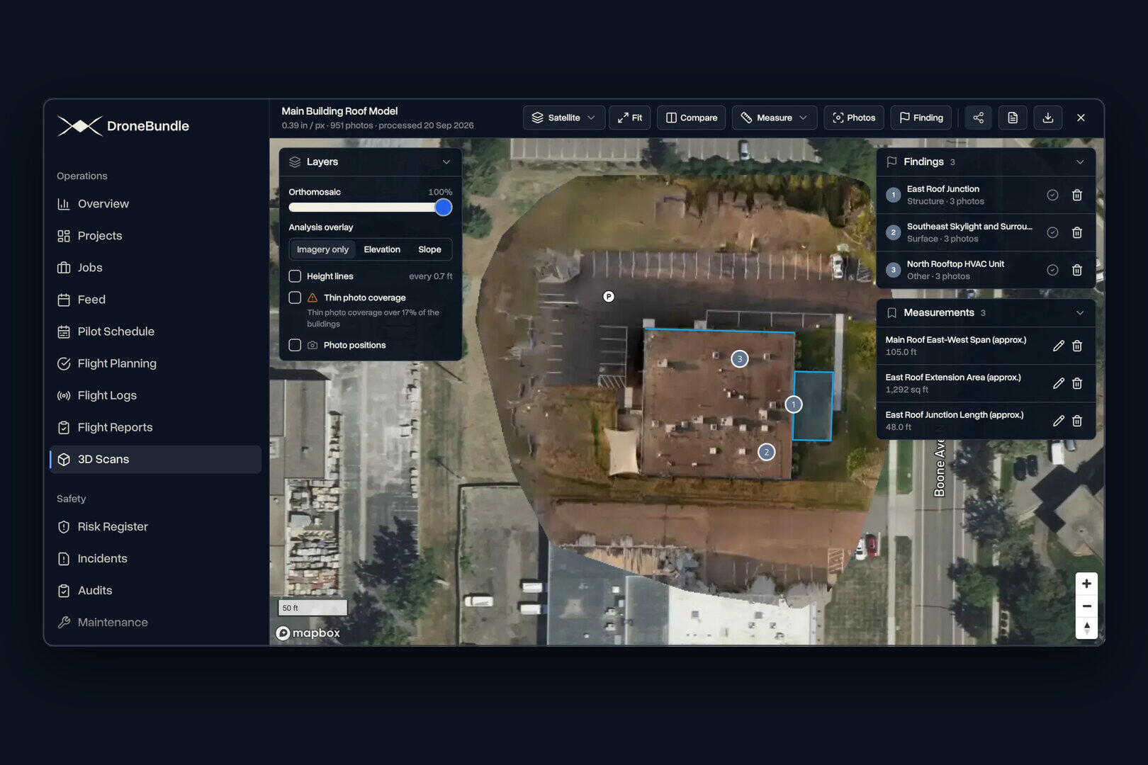
Maps, 3D models and thermal maps from one upload. Add 10 to 1,500 overlapping photos to a job, one by one or as ZIP archives, and 3D Scans builds a measurable map with elevation and slope, a textured 3D model you can orbit, or a thermal map from supported DJI thermal photos. Processing runs in the cloud, so nobody waits on a workstation. Small sets finish in minutes, and you get a notification when a larger scan is ready.
A viewer built for answers. Switch between imagery, elevation and slope, turn on height lines, and see where each photo was taken. Measure distance, area, height, profiles, roofs and volumes, and every result is saved with the scan. Compare two scans on the same job, or set a thermal map against the visible-light scan. Areas with thin photo coverage are marked on the map, so you know which parts to trust before a number goes to a client.
Findings with the evidence attached. Click any spot on the scan to pull up the original photos that captured it. Pin a finding or outline an area, give it a condition rating, notes and an estimated repair cost, and track its status. The relevant photos attach themselves.
Client reports and share links. Measurements, findings and photos go into a PDF with your overview, your recommendations and your branding, with a page preview before you export. Or send a browser link, and the client explores the scan without creating an account.
Processing priced by photos, not megapixels. Enterprise includes 200 processing credits a month, and a scan uses one credit per 100 photos, so the plan covers 20,000 photos a month. A 48-megapixel camera costs exactly what a 12-megapixel camera costs, and you see the credit cost before processing starts.
Your files, in standard formats. Maps, point clouds, surface and terrain models, textured 3D models and the processing report are saved as ordinary job files and download in standard formats for use in other mapping and modeling tools. With data ownership switched on, every file also copies to your own cloud storage.
The operation around the map. Work runs as projects and jobs, with a pilot schedule by week. US jobs show FAA airspace, LAANC heights and live TFRs on the job map. Flight logs from DJI, PX4, ArduPilot, Autel and Parrot aircraft become flight records with 3D replay, clients get their own logins through a client portal, and jobs are invoiced from the work you flew.
DroneBundle is the only platform on this list that schedules the pilot, builds the map and invoices the client. Legacy Technology Lab runs its roof inspection program this way, with more than 20,000 commercial roof inspections expected in 2026 across 1.4 billion square feet (case study). Our guide to making a 3D model from drone photos covers the capture side.
The best alternatives by job
The eight alternatives below each specialize in one part of mapping. Several of them sit alongside DroneBundle, which runs the jobs, pilots and clients around whichever engine a team already owns.
2. DroneDeploy: best for construction site documentation
DroneDeploy is best for construction teams that document the same sites again and again. It combines a flight app, cloud processing and progress tools, and Procore has owned it since completing the acquisition on September 9, 2026.
It publishes two prices: $4,188 a year for the single-user Individual plan and $1,908 a year for Ag Lite. Every team plan is quote-only (archived pricing page). Processing allowances are counted in gigapixels a year, so a higher-resolution camera uses them up faster.
DroneBundle counts photos instead of pixels, and adds client logins and invoicing on the same job. Our DroneDeploy pricing breakdown explains the limits, and the DroneBundle vs DroneDeploy comparison lists every feature side by side.
3. Pix4D: best for survey-grade processing control
Pix4D is best for survey and engineering teams that want to set every processing parameter themselves. PIX4Dmatic runs on your own computer: Standard, the cheapest plan that makes an orthomosaic, is $3,990 a year, and Pro, which adds terrain models and contours, is $4,990. PIX4Dmapper is still sold at $3,990 a year, and PIX4Dcloud starts at $1,290 a year with 500 processing credits.
A free 15-day plan needs no credit card. Our Pix4D pricing guide covers every plan and how cloud credits are spent, and survey work still depends on well-placed ground control points whichever engine you choose.
4. Agisoft Metashape: best one-time license
Agisoft Metashape is best for teams that would rather buy software once than subscribe. Agisoft lists Metashape Standard at $179 and Professional at $3,499, both node-locked to one computer.
Professional is the edition built for mapping and GIS work, with point cloud and multispectral processing, while Standard suits visual 3D models. You supply the workstation and the hours. Our drone photogrammetry software comparison walks through what processing a 400-image site looks like in practice.
5. DJI Terra: best for DJI cameras and Zenmuse LiDAR
DJI Terra is best for DJI fleets flying Zenmuse LiDAR or DJI mapping cameras. It is Windows desktop software at $1,850 a year for Standard or $3,700 a year for Flagship in the US, with permanent licenses from $5,280. Zenmuse L2 and L3 point cloud processing is free.
Terra is built around DJI hardware and needs an NVIDIA graphics card. It also stopped planning mapping flights in version 5.0. Our DJI Terra guide covers every edition, and our LiDAR drone guide explains when LiDAR beats photos.
6. RealityScan: best for very large photo sets
RealityScan is best for teams processing thousands of images at once. Formerly sold as RealityCapture, it is known for fast alignment on large sets and for combining drone photos with terrestrial laser scans, which suits digital twins of complex structures.
Epic Games makes it free for companies under $1 million in annual revenue and charges $1,250 per seat a year above that. It is desktop software, so the graphics card, the storage and the processing time are yours to manage.
7. Propeller: best for earthworks and mining
Propeller is best for earthworks, aggregates and mining teams that measure stockpile volumes and track grade against a design surface. Platform pricing is by quote, and its AeroPoints smart ground control targets are bought separately.
Its tools are built for civil and mining sites, so inspection and energy programs would use a small part of it. Our construction mapping buyer's guide covers that side of the market.
8. WebODM: best free drone mapping software
WebODM is best for teams that want open-source processing with no license fee. WebODM and the OpenDroneMap engine behind it are free to run on your own hardware, which you set up and maintain yourself.
Its cloud service, WebODM Lightning, does the processing for you. Plans run from $24 a month billed yearly for 12 maps every 30 days, or $35 for unlimited maps, with up to 1,500 images per map (3,000 on the $99 Business plan).
9. SkyeBrowse: best for quick 3D models from video
SkyeBrowse is best for fast 3D documentation, such as public safety scenes, built from drone video rather than photos. Paid models cost $24.99 on Commercial, $49.99 on Pro and $199 on Public Safety & Enterprise, and a free tier keeps models for 30 days.
Pricing is per model, so the bill rises with every site you document.
What one mapping job costs on each pricing model
The same 600-photo site costs nothing extra on some platforms and a large slice of a yearly allowance on others, because each vendor counts usage differently. Here is that one job flown twice, once with a 20-megapixel camera and once with a 48-megapixel camera.
| Platform | What it counts | 600 photos at 20 MP | 600 photos at 48 MP |
|---|---|---|---|
| DroneBundle Enterprise | One credit per 100 photos | 6 of 200 credits | 6 of 200 credits |
| DroneDeploy Individual | Gigapixels processed per year | 12 of 2,000 gigapixels | 28.8 of 2,000 gigapixels |
| PIX4Dcloud | Credits: megapixels times images, over 100 | 120 credits | 288 credits |
| WebODM Lightning | Maps per 30 days | 1 of 12 maps | 1 of 12 maps |
| SkyeBrowse | Each model | $24.99 to $199 | $24.99 to $199 |
| Metashape, RealityScan, DJI Terra, WebODM | A license, then your own computer | No fee per job | No fee per job |
On DroneBundle, 200 credits a month cover 33 of these jobs whichever camera you fly. On PIX4Dcloud's entry plan, 500 credits a year cover four of them at 20 megapixels and one at 48.
Over a year, the DroneBundle allowance adds up to 240,000 photos. PIX4Dcloud Pro's 2,500 yearly credits cover about 12,500 photos at 20 megapixels.
DroneDeploy's Individual allowance of 2,000 gigapixels a year stretches to about 166 of these jobs at 20 megapixels and about 69 at 48, which is roughly 100,000 photos a year on the smaller camera and 42,000 on the larger. The camera decides the bill, which is worth knowing before you upgrade an aircraft mid-contract.
Desktop tools have no meter at all. What they cost instead is a workstation and the hours someone spends running it.
Free drone mapping software
WebODM is the best free drone mapping software, because it is open source and puts no cap on photos or maps when you run it on your own computer. The other free options are free with a condition attached.
- WebODM and OpenDroneMap: free and open source, with setup and hardware on you.
- RealityScan: free for companies under $1 million in annual revenue.
- DJI Terra: processes Zenmuse L2 and L3 point clouds at no charge. Photo mapping needs a paid license.
- SkyeBrowse: a free tier that keeps models for 30 days.
- Pix4D: a free 15-day plan with no credit card.
- DroneBundle: a 14-day free trial with every Enterprise feature and 20 processing credits, enough for 2,000 photos, with no credit card.
Free processing still has a cost. Someone has to own the workstation, learn the settings and wait for the run to finish, which is the trade the cloud platforms exist to remove.
Drone mapping apps for flying the mission
A drone mapping app flies the grid and takes the overlapping photos, and the mapping software turns those photos into a map. They are often two different products.
- DJI Pilot 2 plans area and linear mapping routes on DJI's enterprise aircraft.
- DroneDeploy's flight app automates capture on the drones it supports, including the DJI Matrice 4E and Mavic 3 Enterprise RTK.
- UgCS is a desktop mission planner used for terrain following and long corridors.
- DJI Terra no longer plans flights since version 5.0, and Pix4D has discontinued PIX4Dcapture.
DroneBundle handles the planning that sits around the flight. The job area goes on the airspace map with FAA airspace, LAANC heights and live TFRs, the pilot is scheduled, and the flight is approved before anyone drives to site. Afterwards the flight log and the photos land on the same job. Our guide to drone flight planner apps compares the capture tools.
Any mapping flight flown for a client is a commercial operation under Part 107 in the US, whichever app flies it.
Before you sell a map: accuracy and licensing
Mapping software produces measurements, and two things decide whether a client can rely on them: how the accuracy was checked, and who is allowed to certify the result.
Accuracy is stated against a standard. In the US that is the ASPRS Positional Accuracy Standards, which report accuracy as root-mean-square error against independent checkpoints and include an addendum for mapping with drones. Image resolution alone tells you how sharp a map looks, not how well it lines up with the ground.
Surveying is a licensed profession. In 360 Virtual Drone Services v. Ritter, the Fourth Circuit upheld North Carolina's licensing rules against a drone operator selling measurable maps, and the Supreme Court declined to review the case in April 2026. State rules differ, so check yours before you advertise measurements as survey deliverables.
Our drone surveying software guide explains the business models that work for firms that need stamped results.
How to choose drone mapping software
Choose drone mapping software by what leaves your office at the end of the job, because the deliverable decides which strengths matter.
Inspection and service companies. DroneBundle Enterprise. The scan, the findings, the branded report and the invoice live on one job, and the client gets a login or a share link. Our drone roof inspection software guide shows the workflow for roofs.
Enterprise drone programs. DroneBundle Enterprise. Maps and thermal maps sit beside pilot scheduling, flight records, maintenance and dock flights, so a program runs on one platform. Our ranking of the best drone management software covers the operations side.
Survey firms that stamp deliverables. Pix4D or Metashape for the processing, with DroneBundle running the jobs, pilots, flight records and invoices around them. The surveying and inspection page shows how multi-site work is organized.
Construction owners already on Procore. DroneDeploy, for its place in that ecosystem. Our list of DroneDeploy alternatives covers what to ask before renewing.
DJI LiDAR fleets. DJI Terra for the point clouds, since Zenmuse processing is free.
One-off projects and tight budgets. WebODM if you have the hardware, or RealityScan if your revenue is under the threshold.
Frequently asked questions
What is the best drone mapping software?
DroneBundle is the best drone mapping software for teams that deliver maps and 3D models to clients, because it builds measurable maps, textured 3D models and thermal maps on the same job as the pilots, flight records, clients and invoices. For processing only, Pix4D gives the most control, Agisoft Metashape is the cheapest one-time license, and WebODM is free and open source.
Is there free drone mapping software?
Yes. WebODM and OpenDroneMap are open source and free to run on your own computer, and RealityScan is free for companies under $1 million in annual revenue. DroneBundle offers a 14-day free trial with every Enterprise feature and 20 processing credits, with no credit card required.
How much does drone mapping software cost?
Drone mapping software costs from nothing to about $5,000 a year per seat. Metashape is a one-time $179 or $3,499, PIX4Dmatic is $3,990 to $4,990 a year, DJI Terra is $1,850 to $3,700 a year, and DroneDeploy's single-user plan is $4,188 a year. DroneBundle uses flat tiers from $149 a month for the whole team, and Enterprise includes mapping with processing for 20,000 photos a month.
Can drone mapping software make 3D models?
Yes. The same overlapping photos that make a 2D map can produce a textured 3D model and a point cloud. DroneBundle builds the map and the 3D model from one upload, and angled photos of walls and roof edges improve the model.
Ready to map, measure and invoice from one job?
Most mapping tools hand you a file and leave the rest to you. DroneBundle builds the map, 3D model or thermal map on the job, keeps the measurements and findings with it, and sends the report and the invoice from the same place, with processing priced by photo count.
Start a 14-day free trial with 20 processing credits and no credit card to scan a real site on a real job, or book a live demo to see a scan go from photos to a client report.