DJI Terra is DJI's Windows desktop software for turning drone photos and DJI LiDAR data into orthomosaics, 3D models and point clouds. In the US it costs $1,850 a year for the Standard edition or $3,700 a year for Flagship, with permanent licences at $5,280 and $10,580. Since version 5.0 it is a processing tool first: general flight route planning was removed in July 2025.
Terra started out as a plan-fly-process package, with flight planning built in. That is no longer how it works. The current release, V5.3.5 (August 2026), processes visible-light photos, Zenmuse LiDAR data, multispectral imagery and, since July 2026, thermal photos into 2D temperature maps. Mapping missions are now planned in DJI Pilot 2 or FlightHub 2, not in Terra.
This guide covers what DJI Terra does today, what each edition costs, what changed across version 5, the licence rules that cause problems once more than one person uses it, and the parts of a mapping job Terra was never built to handle.
What DJI Terra does
DJI Terra is a reconstruction engine. You import photos or LiDAR data from a finished flight, and it produces maps, models and point clouds on your own computer, with no upload to a cloud service.
It handles five kinds of task:
- 2D visible-light reconstruction. Orthomosaics and digital surface models, delivered as GeoTIFF in a UTM projection. If you are new to the deliverable, our guide to orthomosaic images explains what the client receives.
- 3D visible-light reconstruction. Textured meshes (OBJ, FBX, PLY, I3S), tiled level-of-detail models (OSGB, B3DM, S3MB) and point clouds (LAS, LAZ, PNTS).
- LiDAR point clouds. Data from DJI Zenmuse L1, L2 and L3 sensors becomes classified point clouds, DEMs and contours.
- Multispectral maps. Band and vegetation index maps from the Mavic 3 Multispectral and Phantom 4 Multispectral.
- Gaussian splatting. Photorealistic radiance-field scenes, on the Flagship edition only.
Version 5.3 added a sixth: thermal 2D reconstruction. According to DJI's July 2026 update notes, Terra now builds temperature maps from paired thermal and visible photos taken by the Mavic 3T, Matrice 3TD, Matrice 4T and 4TD and the Zenmuse H20T, H20N and H30T, with point, line and area temperature tools and emissivity correction. The same release added rolling-shutter correction and video-based 3D modelling.
Terra also reads ground control points. The DJI Terra FAQ asks for at least three GCPs for absolute orientation and recommends four or more per area. Checkpoint errors appear in the quality report, which is the document a surveyor will ask for. Our ground control points guide covers placement.
DJI Terra editions and pricing in 2026
DJI Terra comes in four commercial editions: Agriculture, Standard, Flagship and Cluster, plus an Education licence. Version 5.0 renamed the two main ones. Standard replaced Pro, and Flagship replaced Electricity, and existing Pro and Electricity holders moved across at no charge.
These are the US prices on the DJI Store in October 2026:
| Edition | Annual | Permanent | What it adds |
|---|---|---|---|
| Agriculture | $300 | Not sold | Agricultural applications and multispectral work; 3 devices per licence |
| Standard | $1,850 | $5,280 | 2D and 3D photogrammetry, LiDAR processing, cluster processing (free since V5.1) |
| Flagship | $3,700 | $10,580 | Everything in Standard plus Gaussian splatting and the Electricity application |
| Standard + DJI Modify Flagship | $2,780 | $7,890 | Standard plus DJI's mesh editing software |
| Flagship + DJI Modify Flagship | $4,440 | $12,650 | Flagship plus DJI Modify |
| Cluster, offline and Education | Via dealers | Via dealers | Offline activation, multi-machine cluster licences, academic use |
A few details shape the real price.
The DJI Store sells online licences only. Each one binds to one DJI account and one computer. Offline licences, which work on air-gapped machines, are sold through enterprise dealers, and dealer prices vary.
Some LiDAR work is free. DJI's FAQ says Zenmuse L2 point cloud processing, including accuracy optimisation, costs nothing, and the V5.1 release notes say LiDAR point cloud tasks "can now be reconstructed for free", the same release that added the Zenmuse L3. A team that only flies an L2 or L3 may not need a paid edition for point clouds at all. The FAQ's pricing is stated as of V5.0, when Zenmuse L1 users got basic point clouds free but needed Standard or above for accuracy optimisation, so L1 owners should check the current release notes before buying.
The free trial runs for one month on one computer. It refuses reconstructions of more than 500 photos and caps LiDAR imports at 8 GB, so it will not tell you how Terra behaves on a full production dataset.
Annual or permanent licence: the break-even
A permanent licence pays for itself in just under three years. Standard at $5,280 equals 2.85 years of the $1,850 annual fee, and Flagship at $10,580 equals 2.86 years of the $3,700 fee.
That arithmetic used to be worse. Before version 5, a permanent licence included one year of updates; after that you paid an annual maintenance fee (the old Pro permanent fee was $440 a year) or stayed on the version you had. DJI dropped maintenance fees with V5.0, so permanent holders now get updates at no cost.
There is a caveat in the small print. The DJI Terra FAQ says its pricing information is based on V5.0, and that whether future features are free or paid "will be specified in the release notes at the time of publication." A permanent licence buys the current feature set, not a promise about the next one.
Three questions settle the choice:
- Will the work still be there in three years? Annual suits project-based or seasonal mapping. Permanent suits a standing survey or inspection program.
- Will the hardware still be there? Terra's newest features target thermal and LiDAR payloads. In July 2026 the FCC opened PS Docket 26-189, which proposes ending continued import and marketing of previously authorised Covered List drones and components with thermal cameras, LiDAR or docks. Drones you already own are not affected, and no final decision had been published by early October 2026. Terra itself is software. But a permanent Flagship licence is worth less if you cannot replace the aircraft that feed it. Our DJI ban explainer covers the wider picture.
- Will the computer still be there? Licences bind to hardware, which the next sections explain.
What changed in DJI Terra version 5
Version 5 changed Terra from a planning-and-processing suite into a processing suite with a new licence structure. These are the releases since July 2025, from DJI's release notes:
| Version | Released | What changed |
|---|---|---|
| 5.0.0 | 17 July 2025 | Standard and Flagship replace Pro and Electricity; Gaussian splatting on Flagship; new interface; FBX and LAZ export; no more maintenance fees; route planning reduced to Detailed Inspection and Agricultural tasks |
| 5.1.0 | 4 Nov 2025 | Zenmuse L3 support; LiDAR point cloud reconstruction made free; cluster processing free for Standard and Flagship |
| 5.2.0 | March 2026 | HEIF photo import, Cloud Optimized GeoTIFF output, automatic D-RTK 3 marker identification |
| 5.2.5 | May 2026 | Cloud PPK base station data saved locally during LiDAR processing, improved long-range LiDAR point cloud quality |
| 5.3.0 | July 2026 | Thermal 2D reconstruction, rolling-shutter correction, video-based 3D modelling, Gaussian splatting on clusters, in-app AI assistant |
| 5.3.5 | 20 Aug 2026 | Current release: Zenmuse L3 dataset optimisation for better horizontal accuracy; also offered bundled with DJI Modify 1.6.0 and DJI Reality 1.0.1 |
The change that matters most for operations is the one buried in the 5.0 notes. Terra no longer plans mapping flights. DJI's own notes tell users who need general route planning to stay on an earlier version (the release notes point to 4.5.0). In practice, that means planning the grid or oblique mission in DJI Pilot 2 on the controller, or in DJI FlightHub 2 for docks and teams.
So the flight plan, the flight log and the processed map now live in three different tools. That is fine for one pilot. For a team, someone has to tie them back together, and our drone flight planner guide looks at how to keep planning consistent across pilots.
Two smaller notes from the same release matter if you run older projects. Tasks created in V5.1 cannot be continued in earlier versions. And continuing a pre-5.1 project in 5.1 or later clears the previous reconstruction results, so archive outputs before you upgrade a workstation mid-project.
System requirements and the workstation you need
DJI Terra needs 64-bit Windows 10 or later, at least 32 GB of RAM and an NVIDIA graphics card with 4 GB of video memory and compute capability 6.1 or above. DJI recommends 64 GB of RAM and an RTX 2070 or better.
There is no Mac version. AMD and other non-NVIDIA graphics cards are not supported, and since V3.9 a licence can only be obtained on a computer with an NVIDIA card. Mac-based teams need a separate Windows workstation.
Memory sets the job size. DJI's FAQ says each additional 10 GB of free memory lets Terra process about 4,000 more photos. Gaussian splatting runs on the 32 GB / 4 GB minimum, but DJI recommends 8 GB of video memory or more for it.
Budget the workstation as part of the licence cost. A machine at DJI's recommended spec is a separate purchase for most teams, and LiDAR projects need fast storage for raw data folders that easily run to tens of gigabytes. Cluster processing, now free on Standard and Flagship, spreads a job across several Terra machines on the same local network, but every worker needs a licence with the right permissions.
Licence rules that catch teams out
DJI Terra licences are tied to a person's DJI account and a specific computer. That works for an owner-operator. It causes friction in a company where people, laptops and job sites change.
An online licence stops working after three days offline. DJI's release notes have stated this since V4.0. A crew processing on a laptop at a remote site with no signal has a three-day window. Offline licences avoid this but come only through dealers, and offline mode loses GEO zone unlocking, map loading and location search.
The licence belongs to one DJI account, and the account cannot be changed. The DJI Store says so in its purchase notes. If the licence was activated on a pilot's personal DJI account and that pilot leaves, recovering it is a support conversation, not a setting. Activate company licences on a company-controlled DJI account from day one.
The licence binds to the computer's hardware. Replacing a CPU or moving the hard disk invalidates the binding. A one-device licence can be unbound once per calendar year; a three-device Agriculture licence twice. A failed laptop in January and a hardware upgrade in June can leave you stuck.
Activated licences are not refundable. The DJI Store's terms rule out returns and refunds once a licence is activated, so buy the edition you need rather than the one you hope to grow into.
None of this is unusual for desktop software. It just needs an owner. Record each licence like any other company asset: which edition, which DJI account, which machine, when it renews. If you already track aircraft and batteries in an equipment register, keep the Terra seats on the same list.
Which drones and cameras work with DJI Terra
DJI Terra is built around DJI hardware, and it works best with it. Supported sources include the Matrice 4E, 4T, 4D and 4TD, the Mavic 3 Enterprise series, the Matrice 350 RTK with the Zenmuse P1, and the Zenmuse L1, L2 and L3 LiDAR payloads.
Photos from other drones are a grey area. DJI's FAQ answers "theoretically yes" for 3D models from non-DJI drones, with a warning that results may be worse. Since V3.6 you can enter a third-party camera's intrinsic parameters to help. LiDAR reconstruction is built around DJI's Zenmuse sensors, although the FAQ says third-party point clouds can be imported as LAS files.
Specialised outputs are hardware-specific:
| Output | Supported sources |
|---|---|
| Multispectral maps | Mavic 3 Multispectral, Phantom 4 Multispectral |
| Thermal 2D maps (V5.3+) | Mavic 3T, Matrice 3TD, Matrice 4T, 4TD, Zenmuse H20T, H20N, H30T |
| LiDAR point clouds | Zenmuse L1, L2, L3 |
| Rolling-shutter correction | Matrice 4T and 4TD |
DJI's July 2026 notes still recommend the mechanical-shutter Matrice 4E where survey-grade accuracy matters. In its own rolling-shutter tests with the Matrice 4T, DJI reports horizontal accuracy of about 3 to 4 times the ground sample distance and vertical accuracy of 4 to 5 times. That is useful for inspection maps. It is not a survey. Our Matrice 4T guide covers the camera trade-offs, and the LiDAR drone buyer's guide compares the Zenmuse sensors.
Where DJI Terra stops
DJI Terra ends at a folder of output files on one Windows machine. Everything that turns those files into a delivered, paid, defensible job happens somewhere else.
Accuracy is your claim, not the software's
Terra produces a quality report. It does not sign anything. Whether a map can be sold as measurement depends on how it was controlled and who stands behind it.
That is a legal question as well as a technical one. In North Carolina, the state surveying board told a drone operator that selling measurable maps without a surveying licence was unlicensed surveying. The operator argued that this violated the First Amendment, and the Fourth Circuit rejected that challenge in May 2024. The Supreme Court declined to hear the appeal in April 2026. Other states' surveying laws can reach the same work. If you sell Terra outputs with dimensions on them, read our drone surveying software guide on licensure and accuracy standards, and use independent checkpoints, controlled with RTK or PPK, to prove the numbers.
The job around the map
Terra knows nothing about the client, the site, the pilot who flew it or the aircraft used. It does not record the flight log that proves the capture happened legally, deliver the map to the client, or send the invoice.
Those records matter later. A client disputes a stockpile volume six months on. An insurer asks which aircraft flew the site. A regulator asks for the flight record. If the answer lives in a Terra project folder on one laptop, a Pilot 2 export on another, and an email thread, assembling it takes days.
Sharing and storage
Terra saves results locally. DJI Reality and DJI Modify view and edit models, but getting a 20 GB tiled model or point cloud to a client still means a file transfer and a backup plan. Decide where the authoritative copy lives before the first project, not after the first lost drive.
DJI Terra alternatives compared
DJI Terra competes with desktop photogrammetry suites and cloud mapping platforms. The right choice depends on your hardware, your accuracy requirements and how many people touch the data.
| Tool | Runs where | Best for | Main limits |
|---|---|---|---|
| DJI Terra | Windows desktop | DJI fleets, Zenmuse LiDAR, local processing | DJI hardware focus, Windows and NVIDIA only, no mapping routes |
| Pix4D | Desktop and cloud | Survey-grade photogrammetry, mixed hardware | Separate products per workflow, steeper learning curve |
| Agisoft Metashape | Desktop | Research, scripting, fine parameter control | No flight planning or collaboration layer |
| DroneDeploy | Cloud | Construction programs, integrations | Individual plan $4,188/yr, gigapixel limits, quote-only team plans |
| DroneBundle 3D Scans | Cloud, inside the job | Roof, building and site scans tied to jobs and reports | Photos only (10 to 1,500), no GCP input, no LiDAR |
For a deeper comparison of processing engines, see our drone photogrammetry software guide. For what the cloud option really costs per map, our DroneDeploy pricing breakdown works through the numbers.
Running DJI Terra inside a commercial operation
Terra is a strong choice for DJI-standardised teams that need LiDAR, local processing or Gaussian splatting. What it needs alongside it is a system for the job itself.
That is the layer DroneBundle covers. Each mapping job holds the client, the site, the assigned pilots and aircraft, the weather forecast and the compliance checks. DJI flight log processing (on the Professional plan and above) attaches each flight's record after landing; synced flights are matched to a job where possible, and unmatched ones wait for someone to link them. Terra outputs can be uploaded to the same job as files, shared with the client through the client portal, and invoiced from the same record. With Data Ownership, every file is also mirrored to an S3 bucket in your own cloud account.
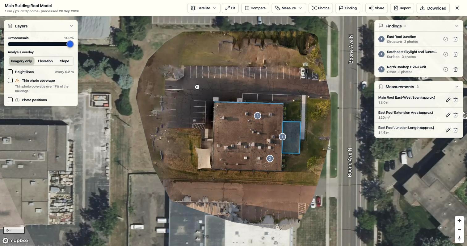
For photo-based work that does not need LiDAR or GCPs, DroneBundle 3D Scans can replace the Terra step altogether. It builds measurable maps, textured 3D models and thermal maps from supported DJI thermal photos on the job, with measurements, photo-linked findings and branded PDF reports. It is included on Enterprise with 200 processing credits a month, and one credit covers up to 100 photos. Our 3D model capture guide and thermal mapping guide cover the flying side either way.
Legacy Technology Lab is a good example of why the job layer matters at volume. It expects more than 20,000 commercial roof inspections in 2026 across 1.4 billion square feet, and it uses DroneBundle to coordinate missions, pilots and documentation. The Legacy Technology Lab case study has the detail, and our surveying and inspection page shows the grid and corridor templates and recurring inspection scheduling that survey teams use.
Frequently asked questions
Is DJI Terra free?
No, but parts of it are. DJI Terra Standard costs $1,850 a year and Flagship $3,700 a year in the US. Zenmuse L2 point cloud processing is free, LiDAR point cloud reconstruction has been free since V5.1 (which added the Zenmuse L3), and a one-month trial covers jobs of up to 500 photos.
What is the difference between DJI Terra Standard and Flagship?
Flagship adds Gaussian splatting and the Electricity application for power line inspection and modelling. Both include 2D and 3D photogrammetry, LiDAR processing and cluster processing. Flagship costs twice as much: $3,700 a year against $1,850.
Can DJI Terra plan drone flights?
Not mapping flights, since version 5.0. DJI Terra now only plans Detailed Inspection and Agricultural tasks. Grid, oblique and corridor mapping missions are planned in DJI Pilot 2 or DJI FlightHub 2, or in DJI Terra 4.5 and earlier.
Does DJI Terra work on a Mac?
No. DJI Terra runs only on 64-bit Windows 10 or later and requires an NVIDIA graphics card with at least 4 GB of video memory. AMD and other non-NVIDIA cards are not supported, and a licence can only be activated on a computer with an NVIDIA card.
Keep the map attached to the job
DJI Terra does the reconstruction well. The work that decides whether a mapping program is profitable, scheduling pilots, proving compliance, delivering to clients and getting paid, happens outside it. DroneBundle keeps that work on one job record, and on Enterprise it can process photo-based scans in the same place.
Start a 14-day free trial with 20 scan processing credits and no credit card, and file your next mapping job, its flight logs and its Terra outputs in one place. Or book a live demo to see how scans, flight logs and invoices connect in one workspace.