DroneDeploy pricing in 2026 starts at $4,188 a year for the single-user Individual plan and $1,908 a year for Ag Lite. Every other plan (Advanced, Aerial, Aerial Pro, Ground, Ground Pro and Unified) is quote-only. Each plan also carries an annual processing allowance measured in gigapixels, which matters more than the headline price once you fly every week.
DroneDeploy is a cloud mapping platform that says it has been used on 3 million sites in 180 countries. It plans the flight, processes the photos into orthomosaics and 3D models, and shares the results with Procore, Autodesk and Esri. It is also, since 9 September 2026, a Procore company.
Four numbers circulate for DroneDeploy's paid plans: $329, $349, $499 and $649 a month. Each was printed on DroneDeploy's own pricing page at some point. This guide sets out what the published plans cost today, where the old figures came from, how the gigapixel limit works out for real cameras, what you pay per map, and what happens to your data when you stop paying.
DroneDeploy pricing at a glance
DroneDeploy publishes two prices: the Individual (Flight & Analysis) plan at $4,188 a year and the Ag Lite plan at $1,908 a year, both billed annually. Everything else needs a sales conversation. This is the line-up on the DroneDeploy pricing page as of October 2026.
| Plan | Published price | Who it is for | Key limits and inclusions |
|---|---|---|---|
| Ag Lite | $1,908/yr (about $159/mo) | One agriculture pilot | 1,000 images per map, Stand Count (corn V2/V3, soybeans), Live Map, VARI plant health only, email support |
| Individual (Flight & Analysis) | $4,188/yr (about $349/mo) | One pilot, any industry | Single admin user, 3,000 images per map, email and live chat support, no ground (360) capture processing |
| Advanced (Flight & Analysis) | Quote | One pilot needing survey tools | 10,000 images per map, cut/fill vs design surface, vertical facade inspection, radiometric thermal, unlimited GCP mapping |
| Aerial, Aerial Pro | Quote | Drone programs | Maps, 3D models, inspection reports, docked flights, Esri/Autodesk/Procore sync; Pro adds automated GCP tagging |
| Ground, Ground Pro | Quote | Interior and 360 capture | 360 Walks, BIM overlays, phone-based 3D scans |
| Unified | Quote | Aerial plus ground in one | Both of the above in one contract |
Three things on that page are easy to miss.
First, the self-serve plans are one person. The Individual plan is a "single admin user license," and Ag Lite is a "single pilot license." The moment a second pilot needs a login, you are in quote territory.
Second, monthly billing exists but is not printed. DroneDeploy's FAQ says Individual users can pick monthly or annual billing and that annual is cheaper. It does not say how much cheaper.
Third, there is a 14-day free trial with no card required, and verified nonprofits and schools get discounted pricing through DroneDeploy.org.
Why you see $329, $349, $499 and $649
Each of those figures comes from an earlier version of DroneDeploy's pricing page. Archived copies on the Wayback Machine show how the published prices moved:
| Snapshot of the pricing page | Ag Lite (annual) | Individual (annual) | Individual (month to month) | Advanced (annual) |
|---|---|---|---|---|
| July 2023 | $149/mo | $329/mo | $499/mo | $599/mo |
| June 2024 | $149/mo | $329/mo | $499/mo | $599/mo |
| January 2025 | $159/mo | $349/mo | $499/mo | $649/mo |
| June 2025 | $159/mo | $349/mo | $499/mo | Not listed |
| November 2025 to October 2026 | $1,908/yr | $4,188/yr | Not printed | Quote |
So $329 is the 2023 and 2024 annual rate. $349 is the current annual rate expressed per month. $649 was the Advanced plan's annual rate in January 2025, up from $599 in 2023 and 2024; by June 2025 Advanced no longer showed a price.
And $499 was never a separate plan. It was the month-to-month price of the Individual plan, shown as "Buy monthly ($499/month)" next to the annual rate. At that price, paying monthly cost $5,988 a year against $4,188 on annual billing, a 43% premium for flexibility. DroneDeploy no longer prints the monthly figure, so ask for it before you assume monthly billing is the cheap way to test the platform. The free trial is the cheap way.
What the quote-only plans cover
The quote-only plans are where DroneDeploy's survey, team and enterprise features live. Advanced is still sold to individual pilots, but it adds the tools construction and energy work usually depends on: cut/fill against a design surface, vertical facade inspection, radiometric thermal processing, unlimited ground control point mapping and a 10,000-image map limit.
Above that, DroneDeploy organises its plans by capture type:
- Aerial covers drone flights, maps, 3D models, panoramas, inspection reports, docked flights through the Flight app, and export to Esri, Autodesk and Procore.
- Aerial Pro adds survey-grade workflows: automated GCP tagging, in-app accuracy alerts, expert map review and earthworks cut/fill by region.
- Ground and Ground Pro cover 360 walkthroughs, interior maps, BIM comparison and iPhone or iPad 3D scans.
- Unified combines aerial and ground.
Add-ons are priced on top: Progress AI, Safety AI, Dock Automation, robotic automation and the DroneDeploy Firewall for drone hardware. None have a public price.
If you work in agriculture, note what Ag Lite leaves out. Its plant health is VARI only, which works from an ordinary RGB camera. Multispectral indices such as NDVI sat on the Individual plan in DroneDeploy's 2024 agriculture tab, so a multispectral program should price Individual or above. Our agriculture drone software guide covers where farm management systems fit around it.
The gigapixel allowance: how much each plan processes
Every DroneDeploy plan has a yearly processing cap measured in gigapixels (GPx) uploaded per user, set out in the DroneDeploy Fair Usage Policy. One image counts as its megapixels divided by 1,000, so a 20 MP photo is 0.02 GPx and 50 of them make one gigapixel.
| Plan | Yearly allowance per uploader | 20 MP photos per year | 45 MP photos per year | 61 MP photos per year |
|---|---|---|---|---|
| Ag Lite | 1,000 GPx | 50,000 | about 22,000 | about 16,400 |
| Individual | 2,000 GPx | 100,000 | about 44,400 | about 32,800 |
| Advanced | 3,500 GPx | 175,000 | about 77,800 | about 57,400 |
| Project | 3,500 GPx per site | 175,000 per site | about 77,800 per site | about 57,400 per site |
| Teams | 5,000 plus 2,000 per pilot | 250,000 and up | about 111,000 and up | about 82,000 and up |
The 20 MP column is a Mavic 3 Enterprise class camera. The 45 MP column is a DJI Zenmuse P1, and 61 MP is the Sony sensor used on Wingtra survey aircraft. The camera is what decides whether the cap matters.
Here is the same weekly job on two cameras. A contractor wants a 1,000-photo progress map of one site every week, 52 maps a year.
- On a 20 MP camera: 1,000 × 0.02 = 20 GPx per map, 1,040 GPx a year. Comfortably inside the Individual plan's 2,000.
- On a 45 MP P1: 1,000 × 0.045 = 45 GPx per map, 2,340 GPx a year. Over the Individual cap in week 45.
Same site, same schedule, same plan. Upgrading the camera for better ground sampling distance more than doubled the processing bill in gigapixels.
What happens when you go over? There is no published overage rate. The policy says DroneDeploy will notify the account owner to "initiate discussions on adjusting the contract," and that in rare cases of heavy overuse it may restrict or block use. In practice that means a mid-contract upgrade conversation, so budget for it if you fly high-resolution sensors on a schedule.
The same policy has one more line worth reading twice: "All pilot user licenses are designed for up to 2 different drones per month." A single pilot rotating three aircraft through a busy month is outside what the license was designed for.
What DroneDeploy really costs per map
At $4,188 a year, the Individual plan costs about $81 per map if you produce one a week, and $349 per map if you produce one a month. That is the number to compare against desktop software, a processing service or a per-model platform.
| Maps per year | Individual plan cost per map | Ag Lite cost per map |
|---|---|---|
| 12 | $349 | $159 |
| 52 | $81 | $37 |
| 150 | $28 | $13 |
| 300 | $14 | $6 |
The per-map cost keeps falling until you hit one of three ceilings: the 3,000-image limit per map, the gigapixel allowance, or the one-user license. For a service company that adds a second pilot, the license is often the first ceiling. A second pilot uploading to the same account is a team quote, not a second $4,188.
Then add what the subscription does not include. You still need a supported aircraft. DroneDeploy calls its processing engine hardware agnostic, but its supported hardware page lists automated flight in the DroneDeploy app only for certain models, such as the DJI Matrice 4 Enterprise, Mavic 3 Enterprise RTK and Anzu Raptor RTK. The Skydio X10 is listed as processing only, with data transferred through Skydio Sync. If your program is moving off DJI because of the US foreign drone restrictions, check which workflow your aircraft gets before you sign. RTK aircraft, GCP targets and a GNSS rover are separate costs, and real-time kinematic positioning does not remove the need for checkpoints if you are making survey claims.
For a broader view of how cloud and desktop processing compare on cost per deliverable, see our drone photogrammetry software comparison and the drone mapping software buyer's guide for construction.
Cancelling: the 30-day window and your data
When you cancel DroneDeploy, you keep basic access for 30 days, but export and advanced tools are disabled during that window. DroneDeploy's own FAQ tells you to export any data you need before the 30-day period ends. Read together, the safe reading is simple: export everything you want to keep before you cancel, not after.
That matters more than it sounds. A construction client may ask for a progress map from 18 months ago during a dispute. If the only copy lived in a lapsed subscription, the answer is a renewed subscription or nothing. Reactivating a plan restores full access, so the data is not lost immediately, but it is held behind a renewal.
Build an export habit into the job, not the contract:
- Download the orthomosaic GeoTIFF, the point cloud and the 3D model when each map is final.
- Store them with the job record, alongside the original photos.
- Keep the original photos regardless of what the cloud platform keeps. They are the only thing you can reprocess elsewhere.
The data ownership principle applies to every cloud mapping tool, including ours. Your deliverables should exist somewhere you control on the day you stop paying anyone.
Does the Procore acquisition change DroneDeploy pricing?
Not yet, publicly. Procore agreed to buy DroneDeploy for about $845 million in cash in July 2026 and completed the deal on 9 September 2026, according to its SEC filing. DroneDeploy now runs as a wholly owned Procore subsidiary, and the pricing page still shows the same published plans.
If pricing does change, your renewal is where you would feel it first. If your contract renews in the next year, it is reasonable to ask:
- Will the Individual and Ag Lite self-serve plans continue, or will new customers be steered to bundles?
- Are DroneDeploy features moving into Procore licensing, and will non-Procore customers pay the same?
- Will the Autodesk integration keep the same depth now that DroneDeploy is owned by an Autodesk competitor, and will the Esri integration stay as it is?
- Can you lock today's price for a multi-year term, and what is the cap on renewal increases?
None of these have public answers yet. Get the answers in writing. Our overview of drone software companies tracks the wider wave of consolidation, including what happened to platforms that were absorbed or shut down.
What a DroneDeploy subscription does not pay for
DroneDeploy pays for capture and processing. It does not run the business around the map. Enterprise customers can add DroneDeploy's Drone Operations Management through sales, with flight logs, pilot Part 107 details, equipment tracking and pre-flight checklists, but it does not handle client requests or invoicing. For a drone service company, the work before and after each flight is a separate cost centre:
- Before the flight: taking the client request, scheduling a pilot and an aircraft, airspace checks, flight planning approvals and a weather go/no-go.
- Around the fleet: maintenance intervals, battery and equipment records, and the records the FAA can ask a Part 107 operator to produce.
- After the flight: delivering to the client, keeping the job record and invoicing.
That is the operations layer, and it is what DroneBundle is built for. You can run both: DroneDeploy for mapping, and an operations platform for jobs, pilots, fleet, compliance and clients. Our construction drone software guide explains how the two layers fit together.
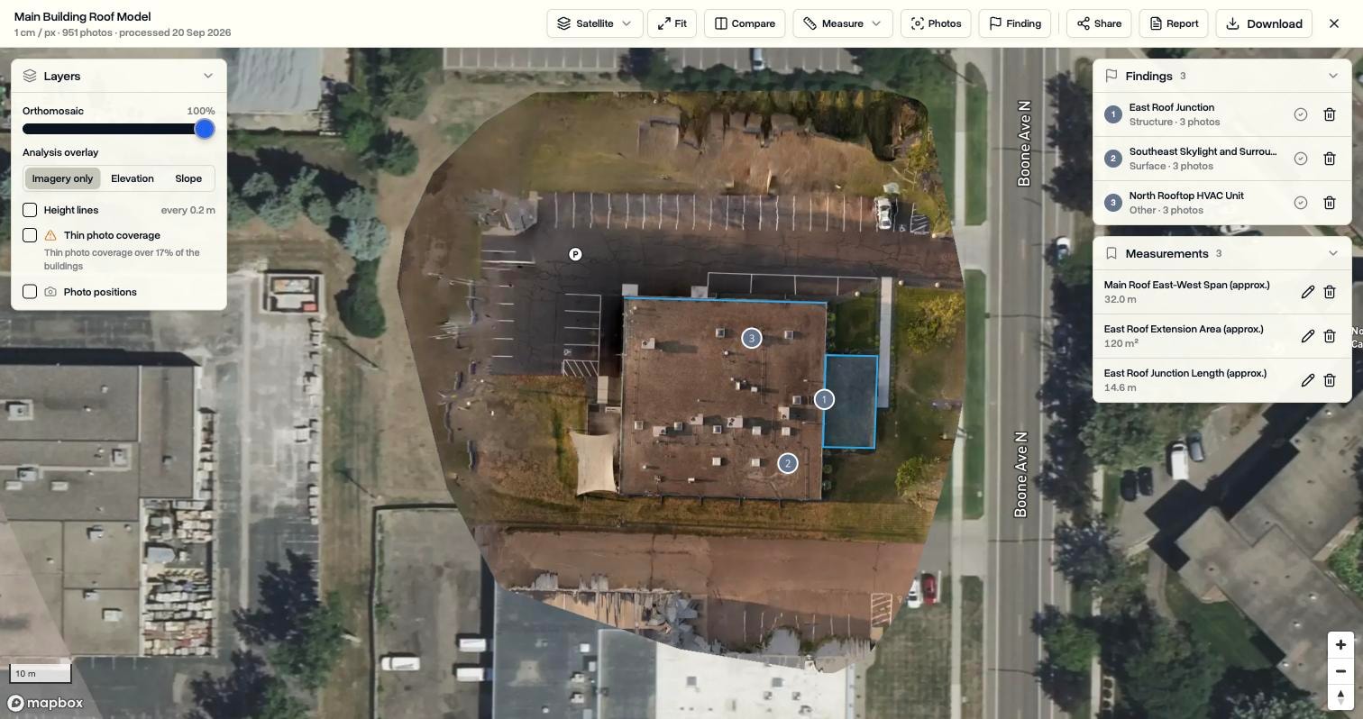
DroneBundle now covers some of the mapping layer too. 3D Scans turns drone photos into maps, textured 3D models and thermal maps on the job, with distance, area, height, roof and volume measurements, photo-linked findings and branded PDF inspection reports. It is priced differently from DroneDeploy:
| What you are comparing | DroneDeploy | DroneBundle 3D Scans |
|---|---|---|
| Which plan includes it | All aerial plans; quote-only above Individual | Enterprise (custom price) and every free trial |
| Processing limit | Gigapixels per user per year | 200 credits a month; one credit per 100 photos |
| Effect of a higher-MP camera | Uses the allowance faster | No effect; credits count photos, not megapixels |
| Photos per map | 1,000 to 10,000 depending on plan | 10 to 1,500 per scan |
| Survey workflows | GCPs, cut/fill vs design (Advanced and above) | No GCP input and no design-surface cut/fill |
| Operations around the job | Logs, pilots and equipment as an add-on | Jobs, pilots, fleet, compliance, client portal, invoicing |
Be clear about the trade. If your core product is survey-grade earthworks with GCPs and design surfaces, DroneDeploy Advanced or Pix4D is the right tool. If you scan roofs, buildings and sites as part of inspection work and want the scan, the findings, the flight logs and the invoice on the same job, DroneBundle's Enterprise plan keeps them together. The 3D model capture guide and thermal mapping guide cover the flying side either way.
Legacy Technology Lab is a good example of the operations-first case. It expects more than 20,000 commercial roof inspections in 2026 across 1.4 billion square feet, and it uses DroneBundle to coordinate missions, pilots and documentation at that volume. The Legacy Technology Lab case study has the detail, and our construction and infrastructure page shows how the same setup works for jobsite programs.
If you do not need 3D Scans, the operations platform starts lower. DroneBundle pricing runs from Starter at $149 a month for up to five team members, through Professional at $499 with DJI flight log processing and client invoicing, to Business at $999 with the full CRM. For help sizing the spend, the drone software ROI calculator works through the maths, and best drone management software for small businesses compares the smaller-team options.
Frequently asked questions
How much does DroneDeploy cost per month?
The Individual plan costs $4,188 a year, which is about $349 a month on annual billing. Ag Lite costs $1,908 a year, about $159 a month. Month-to-month billing is available for Individual users at a higher rate that DroneDeploy no longer publishes; it was $499 a month through mid-2025. Team plans are quote-only.
Is there a free version of DroneDeploy?
No. DroneDeploy has no free plan, but every new user gets a 14-day free trial without a credit card. After cancelling a paid plan you keep view-only access for 30 days, with export disabled, so download your data before you cancel.
What is the difference between DroneDeploy Individual and Advanced?
Advanced adds cut/fill against a design surface, vertical facade inspection, radiometric thermal, unlimited GCP mapping and a 10,000-image map limit, up from 3,000. It also raises the yearly processing allowance from 2,000 to 3,500 gigapixels. Individual has a published price; Advanced is quote-only.
Who owns DroneDeploy now?
Procore Technologies owns DroneDeploy. The deal was announced in July 2026 and completed on 9 September 2026 for about $845 million in cash. DroneDeploy operates as a wholly owned subsidiary, and its published pricing had not changed as of October 2026.
Put the map inside the job
DroneDeploy is strong at producing the map. The cost of a drone program usually builds up elsewhere: scheduling pilots, keeping aircraft maintained, proving compliance, delivering to clients and getting paid. DroneBundle runs that operations layer, and on Enterprise it processes your scans on the same job, priced by photo count rather than camera resolution.
Start a 14-day free trial with 20 processing credits and no credit card to scan a real site and file it against a job, or book a live demo to see how scans, flight logs and invoices connect in one workspace.