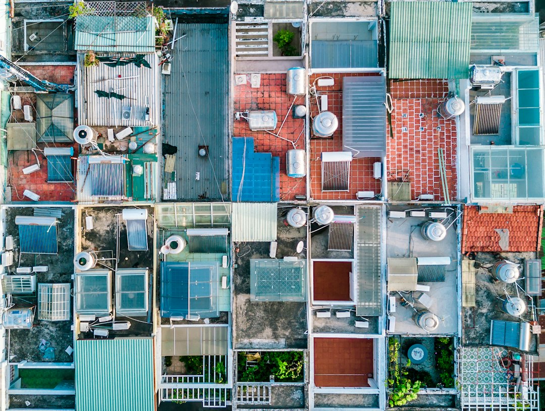
A roof measurement tool gives you a roof's area, pitch and edge lengths without a tape on the roof. Satellite reports are cheapest for simple homes. A drone wins when the imagery is old, the roof is hidden, or the job is commercial. Whichever tool you use, check the number before you order materials.
Every roof measurement tool does the same job: it turns pictures of a roof into area, pitch, and edge lengths for ridges, hips, valleys, rakes and eaves. You can get those pictures from a satellite, a plane, a phone or a drone. The differences are in cost, how recent the pictures are, and how much of the roof they actually show.
This guide compares the four types and works through the accuracy math. It also covers where each one fails and the five-minute check that catches most bad numbers before they turn into a short material order.
Table of contents
- What is a roof measurement tool?
- The four types of roof measurement tool compared
- How accurate is a roof measurement tool?
- Check the imagery date first
- Where roof measurement tools break down
- A five-minute check before you order materials
- When a drone is the better roof measurement tool
- Selling roof measurements as a drone business
- FAQ
What is a roof measurement tool?
A roof measurement tool is software or a service that works out a roof's dimensions from imagery instead of a tape measure. The output is usually a report with total area in squares, pitch for each face, edge lengths and a facet diagram. Many reports also include a material estimate.
Roofers use them to quote without a site visit, order materials and support insurance estimates. They also keep people off roofs. In the US, falls are the leading cause of death in construction, and OSHA reports 389 fatal falls to a lower level out of 1,034 construction deaths in 2024. If you can skip a climb just to measure, skip it.
One unit to keep straight: a roofing square is 100 square feet. A 2,400 square foot roof is 24 squares.
The four types of roof measurement tool compared
The four types are free satellite tools, paid aerial reports, phone apps, and drone photogrammetry. They differ most in where the imagery comes from and when it was taken.
| Tool type | Examples | Typical cost | Turnaround | Main weakness |
|---|---|---|---|---|
| Free satellite tools | Google Earth Pro, free contractor calculators | Free | Seconds to 30 minutes | Footprint only, or an estimate not meant for orders |
| Paid aerial report | Roofr, GAF QuickMeasure, EagleView | About $13-$33 for a small house, more for large or commercial roofs | Under 1 hour to 3 days | Imagery may be months or years old; trees hide edges |
| Phone or ground-photo app | Hover, pitch gauge apps | Subscription or per job | 1 to 12 hours | Needs a site visit; accuracy depends on how you shoot |
| Drone photogrammetry | Your drone plus processing software | Aircraft, software, and a certified pilot | Same day | Needs a Part 107 pilot and a flight |
Prices in this space move often. As of October 2026, Roofr's pricing page lists measurement reports at $19 on its free plan, delivered within 24 hours, and $13 on paid plans. The GAF QuickMeasure app listing says reports start at $18, with single-family reports in under an hour and commercial and multi-family reports in under 24 hours. EagleView's pricing page lists a Bid Perfect report (area, squares and main pitches, without full edge lengths) at $18, full residential roof reports from $24.25 for a small roof to $87 for a large one depending on volume tier, and commercial roof reports at $79 to $89.50.
Free tools come with a catch. A polygon drawn in Google Earth measures the roof's footprint, not the sloped surface you actually shingle, so you supply the pitch yourself. Free calculators that estimate pitch automatically are best treated as ballpark figures for a quote, not for material orders or claims.
How accurate is a roof measurement tool?
A roof measurement tool is only as accurate as its imagery and its pitch reading, and few vendors publish independent tests. Whatever accuracy figure a tool quotes, translate it into squares, because that's what you order.
On a 30-square roof:
- A 2 percent error is 0.6 of a square either way.
- A 5 percent error is 1.5 squares either way. That's four or five bundles of a three-bundle-per-square shingle.
Edge lengths are rarely the big error. Pitch is. True roof area is the footprint multiplied by a pitch factor, and the factor rises fast:
- 6/12 pitch: factor 1.118, so a 2,000 sq ft footprint is 2,236 sq ft.
- 7/12 pitch: factor 1.158, so the same footprint is 2,315 sq ft.
Read that 7/12 roof as 6/12 and you come up about 80 square feet short, close to a full square, from one misjudged pitch. The roof inspection report guide has the full pitch factor table up to 12/12.
So ask whether a tool measured pitch from the imagery or assumed it. That matters more than its headline accuracy figure.
Check the imagery date first
Any roof measurement tool built on satellite or aerial imagery is only as current as the day that imagery was captured. That can be months or years ago, and not every tool puts the date in front of you.
Three things happen to roofs between imagery passes:
- Additions and re-roofs. A new garage, a sunroom or a dormer that isn't in the picture doesn't get measured.
- Storm damage. Imagery from before a hail or wind event shows a healthy roof. That's useless for a claim and misleading for a repair scope.
- Tree growth. A tree that was a sapling in the image may now cover half a rear slope, or the reverse after it was cut down.
Find the date before you trust the number. Some paid reports print the imagery date; if yours doesn't, ask the vendor. In Google Earth Pro, the capture date shows in the status bar, and the historical imagery slider lets you step through older passes. That's handy for seeing when an addition appeared.
If the imagery predates the last storm, the last re-roof, or any construction on the property, it's the wrong source. Order fresh imagery or fly the roof.
Where roof measurement tools break down
Remote roof measurement tools fail in predictable places: tree cover, low-slope commercial roofs, complex roofs with stacked levels, and outbuildings that never made it into the order.
Tree cover. An overhanging canopy hides eaves, valleys and lower roof sections. Reports trace a best guess along the visible edge. Some vendors flag low confidence. Many just deliver a number.
Complex and stacked roofs. Dormers, crickets, roof-over-roof sections and porch roofs tucked under a main eave are hard to see from straight overhead. Oblique aerial imagery helps, but a lower roof shaded by a higher one is a common place for a missed facet.
Outbuildings and scope. Many free tools only measure the main structure. Detached garages, sheds and accessory dwellings may be left out. Paid reports vary in what they count as part of the property. Check what was included.
Low-slope commercial roofs
Flat commercial roofs flip the problem. Pitch barely matters: a typical 1/4 inch per foot drainage slope gives a pitch factor of 1.0002. What matters is everything a top-down picture flattens:
- Parapet walls. Membrane and flashing run up the inside of the parapet. On a 200 by 100 foot roof with 3 foot parapets, that's 600 feet of perimeter times 3 feet, or 1,800 square feet. That adds 18 squares to a 200-square field, about 9 percent that no plan-area number includes.
- Level changes. Several roof levels look like one plane from above. You need the height of each step to scope the wall flashing between them.
- Penetrations and curbs. HVAC units, skylights, hatches and drains each need a count and a curb size. Rooftop equipment also casts shadows that make edges hard to trace in satellite imagery.
- Tapered insulation. Crickets and saddles built with tapered insulation don't show up in a footprint at all.
For commercial roofs, a high-resolution orthomosaic plus a height model is far more useful than a single area figure. You can count the equipment, measure the parapet heights and see the drainage pattern in one place.
A five-minute check before you order materials
You can catch most bad roof measurements with five quick checks from the ground before anyone orders materials. None of them need you on the roof.
- Confirm the imagery date. Compare it against the last storm, re-roof or addition, as above.
- Measure one long edge. Run a tape or measuring wheel along the longest wall below an eave and add the overhang. If it's within a foot or so of the report's eave length, the scale is right.
- Check the pitch on one face. From a ladder at the eave, put a pitch gauge or a phone level app on the rake or a shingle course. If the report says 6/12 and you read 8/12, every face on that slope is wrong.
- Count the features. Walk around and count the facets, dormers, valleys, chimneys, skylights and vent stacks, then compare with the report diagram. Missing features usually mean missing area.
- Look where the camera couldn't. Check under the trees, behind higher roof sections, and at porch and garage roofs. Any section the report left out goes on the list.
If all five pass, order with your usual waste factor. If one fails, re-measure the affected section or fly it.
Write down which checks you ran; "verified eave length and pitch on site" holds up far better in a dispute than "came from the report." The quality assurance guide for drone inspections covers building checks like these into a standard procedure.
When a drone is the better roof measurement tool
A drone is the better roof measurement tool when the imagery has to be current, when trees or stacked roofs hide too much from overhead, or when the roof is large and commercial. In those cases, a satellite report is either out of date or guessing.
It also pays off when you need more than a number: one flight covers measurement, condition photos and the roof inspection itself.
The rules
Flying a drone to measure a roof for a bid or a job is commercial use, even if you're a roofer measuring your own work. The pilot needs an FAA Remote Pilot Certificate under 14 CFR 107.12, which for most people means passing the knowledge test. Our Part 107 study guide covers what's on it.
Two more rules come up on almost every residential roof:
- Airspace. Suburbs near airports often sit in Class D airspace or controlled Class E airspace. Get authorization at scheduling time through LAANC, not in the driveway.
- People. Homeowners and neighbors stand around watching. Under 14 CFR 107.39, you can't fly over people who aren't directly participating unless the operation meets one of the operations-over-people categories. Ask them to step inside or stand clear.
How to fly a roof for measurement
Measurement needs overlapping photos, not just nice ones. A grid of straight-down photos plus an orbit of angled ones lets the software rebuild the roof faces in 3D. High overlap, commonly 70 to 80 percent, is what keeps edges and valleys sharp. Our drone flight planning guide covers mission patterns, and drone photogrammetry software explains what happens to the photos afterwards.
For figures you'll stand behind, tape one or two edges on the ground as a check, and use ground control points when the job calls for survey-grade accuracy. The resolution of a map is not the same as its accuracy.
Measuring from the photos in DroneBundle
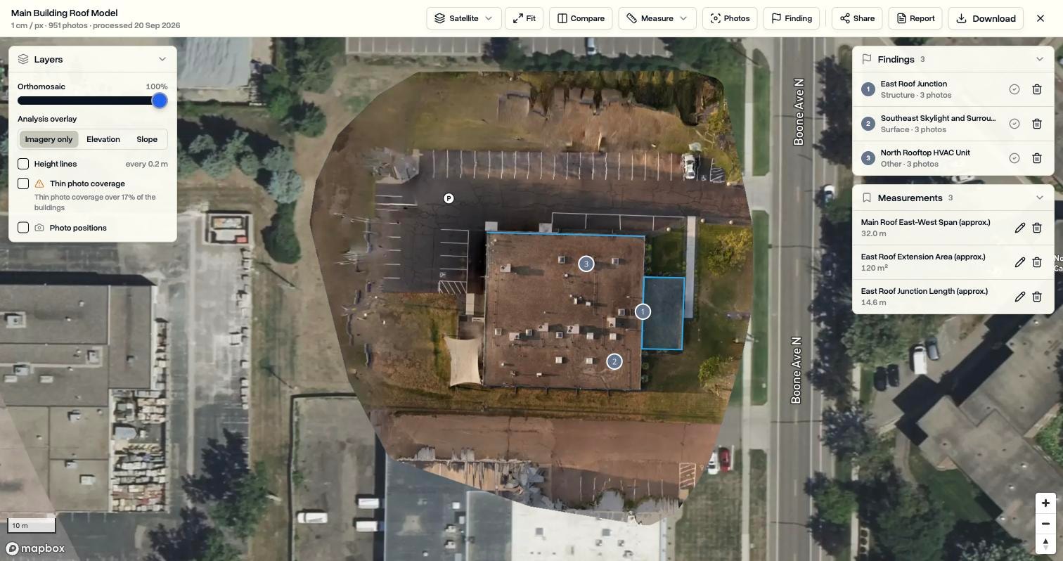
If you already plan and log flights in DroneBundle, 3D Scans turns the photos on a job into a measurable map or 3D model without moving files to another tool. The Roof measure tool traces one roof face and returns its pitch, the direction it faces, and its true surface area instead of only its footprint. The Profile tool draws a line across the roof and charts the height along it, so parapets and steps between levels show up at a glance.
Areas caught by only a few photos are flagged as thin coverage, and saved measurements go into the client report and share link. Our 3D Scans walkthrough shows the full workflow, from starting a scan to sending the PDF.
Selling roof measurements as a drone business
For a drone service company, the satellite report sets the price ceiling on plain measurement. If a roofer can get a simple gable roof measured for under $20 within an hour, a crew visit can't compete on that job. Sell where the drone wins instead.
That usually means four kinds of work:
- Recency. Post-storm work, where imagery older than last week is no use.
- Commercial and complex roofs. Parapets, levels and equipment counts that plan-area reports flatten.
- Measurement bundled with condition. Area and pitch plus findings and photos in one roof inspection report.
- Thermal moisture surveys on low-slope roofs. The thermal mapping guide covers the timing.
Know your client's format. Adjusters and restoration contractors often want an ESX file for Xactimate. If a client needs that, order an ESX report from a vendor that produces them, and sell your imagery and condition data alongside it. The drone roof inspection software guide explains the formats.
At volume, the hard part is no longer measuring. It's scheduling crews, matching flights to properties and getting reports out the door. Legacy Technology Lab expects to run more than 20,000 commercial roof inspections in 2026 across 1.4 billion square feet, using DroneBundle to coordinate pilots and keep documentation tied to each property. For more inspection workflows, see surveying and inspection operations, the drone inspection business guide, and our guide on insurance and liability for commercial drone services before you take on claims work.
FAQ
What is the most accurate roof measurement tool?
For a roof you can fly, a drone model built from well-overlapped photos and checked against a ground measurement is usually the most accurate, and the imagery is from the same day. For a simple house where the imagery is current and not blocked by trees, a paid aerial report is accurate enough for ordering and much cheaper.
Can I measure a roof with Google Earth?
Yes, but Google Earth's polygon tool measures the roof's footprint, not its sloped surface. Multiply the footprint by the pitch factor for each face. A 6/12 roof is about 12 percent larger than its footprint, and a 12/12 roof about 41 percent larger. Also check the imagery date in the status bar before you trust it.
How much does a roof measurement report cost?
As of October 2026, Roofr lists reports at $13 to $19 and GAF QuickMeasure starts at $18. EagleView lists full residential roof reports from $24.25 to $87 depending on roof size and volume tier, and commercial roof reports at $79 to $89.50. Prices change often, so check the vendor's pricing page before you quote.
Do I need a license to measure roofs with a drone?
In the US, yes, if the measurement is for any business purpose. The pilot needs an FAA Remote Pilot Certificate under Part 107, and the drone must be registered. Flying near airports also needs airspace authorization, usually through LAANC.
Measure the roof, then run the whole job from the same place
A cheap satellite number is fine for a simple house. Commercial roofs, post-storm work and anything hidden under trees need fresh imagery, and the measurements are only useful if they end up in the job, the report and the invoice. DroneBundle keeps the flight, the photos, the 3D scan measurements, the findings and the client report on one job record.
The 14-day free trial includes Enterprise features and 20 processing credits for 3D Scans. Each scan uses one credit per 100 photos, so a 250-photo roof flight uses three. Fly your next roof, trace the faces, and see the pitch and true area for yourself.
Start your free trial or book a live demo to walk through a roof scan with the team. Plan details are on the pricing page.