New FeatureNew
3D Scans: Turn Drone Photos into Maps, 3D Models, and Client Reports
3d-scansmappingphotogrammetry3d-modelthermalmeasurementsfindingsinspection-reportroof-inspection
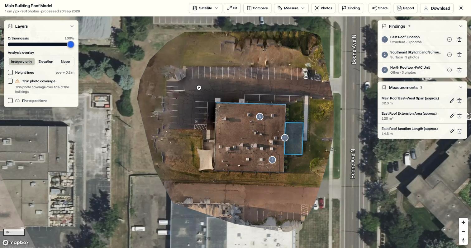
Pick the photos on a job, press Start 3D scan, and DroneBundle builds a map you can measure, a 3D model you can orbit, or a temperature map. Mark what you found, pull up the original photos of any spot, and send the client a report or a link. The photos never leave the job they were flown for.
Start a Scan from the Job
The job already holds the photos, so the job is where they get processed.
- Open a job, go to the 3D Scans tab, and press Start 3D scan
- Choose Map and measurements, 3D model and map, or Thermal map
- Every photo on the job is selected by default, and you can leave out groups or single photos, or add more from the same window
- Zip archives are unpacked into the job first, and identical photos uploaded twice are only counted once
- Takes 10 to 1,500 photos, with up to five scans running at once in a workspace
- A notification tells you when the scan is ready, or why it failed
A Map Sharp Enough to Inspect
A ready scan opens full screen over satellite imagery.
- Processed at the finest resolution the photos allow, around one centimetre per pixel on a typical roof flight
- Elevation and Slope overlays, height lines, and the position every photo was taken from
- Areas caught by too few photos are marked as thin photo coverage, on the scan list and on the map
- Photos with no location, or taken far from the site, are skipped and listed rather than stopping the run
Six Measuring Tools
- Distance, Area, and the Height of any point
- Profile charts the height along a line you draw across the site
- Roof traces one roof face and returns its pitch, the direction it faces, and its true surface area
- Volume measures a stockpile or an excavation against the ground around it
- Save any measurement with a name, adjust it later, and see it in the report
- Every figure follows your workspace's unit setting
See Every Photo of a Spot
- Choose Photos and click anywhere on the map
- Every original photo that captured that spot is listed, the most direct view first, with a ring around the spot itself
- Open one full screen and step through the rest with the arrow keys
Findings with a Condition, a Status, and a Cost
- Pin a spot or outline an area, then add a title, a category, a condition rating, and a note
- The best photos of the spot are attached automatically
- Mark findings open or resolved and add an estimated cost of repair, totalled in the list
- Categories and condition scales are yours to define, and changing them never rewrites older findings
- On a thermal scan, a finding records the temperature at the spot, or the average, lowest, and highest inside an outlined area and the difference to its surroundings
Thermal Maps
- Built from the real temperatures in DJI thermal photos, with the temperature under your cursor shown live
- Change the palette, narrow the range, and highlight everything above a temperature you choose
- Save the view so the scan opens that way for everyone, including the client
- A thermal scan and a regular scan of the same site are paired, with one switch between them and findings shown on both
Reports and Share Links
- The Report editor builds a client-facing PDF with a live preview
- Write an overview and recommendations, choose and order the findings and measurements, and pick the sections to include
- The cover takes the property address as its title, and workspaces with custom branding get their own logo and company name
- Save a layout as a template for the next job
- Share creates a public link the client opens without signing in, with downloads allowed only if you say so, and removing the link closes it immediately
Compare and Download
- Compare puts two scans of the same job on one map with a divider you drag, for before and after or site progress
- The full-resolution map, point cloud, surface and terrain models, 3D model, and processing report are saved to the job as regular files
- They count toward storage like any upload and are included in Data Ownership mirroring
Where It Lives
- The 3D Scans tab on every job, and 3D Scans in the sidebar for every scan in the workspace
- Workspace owners and project managers start scans, record findings, build reports, and create share links
- Operations leads, pilots, and clients with access to the project's files can open scans and download the results
- Available on the Enterprise plan and on every free trial, with nothing to request or set up
- Runs on monthly credits, one credit per 100 photos: 200 a month on Enterprise, 20 on a trial, and failed scans give their credits back